For decades, accessing land records in the beautiful state of Assam was a time-consuming and often frustrating experience. Property owners, farmers, and prospective buyers had to navigate a complex maze of physical registers, make multiple visits to local circle offices, and decipher archaic terminology just to verify basic ownership details.
To modernize this legacy setup, the Revenue and Disaster Management Department of the Government of Assam rolled out a digital transformation of its land administration system, which traces its historical administrative roots all the way back to 1874. At the heart of this modernization is the Integrated Land Records Management System (ILRMS), widely known by citizens as the Dharitree portal (meaning “Digital Land” or “Earth” in Assamese).
Today, the Dharitree Assam portal provides instant, transparent, and secure online access to over 4.3 million digitized Records of Rights (RoR) and cadastral maps across the state’s revenue districts. By bringing these services online, the state government has successfully minimized transaction delays, curbed real estate scams, and simplified the legal and financial due diligence processes associated with property deals.
Whether you are looking to purchase a new plot of land in Guwahati, verify your ancestral family holdings, or track an administrative application, this comprehensive guide will walk you through everything you need to know about navigating Dharitree and Assam’s modern land reforms.
What is Dharitree Assam (ILRMS)?
At its core, Dharitree Assam is the public-facing gateway of the state’s Integrated Land Records Management System (ILRMS). It is not just an isolated website; it is an integrated ecosystem designed to manage the entire lifecycle of land records, from deed registration to mutation and tax collection.
To make this possible, the platform runs on a technical backbone called Landhub, an API gateway of ILRMS that connects various government divisions. This system links the Sub-Registrar Offices (responsible for property registration), local Revenue Circle Offices (responsible for updating mutations and classifications), the Deputy Commissioners (DCs), and the Directorate of Land Records. This interconnected design ensures that whenever a property transaction is registered, the data is automatically updated across all relevant government registers.
To design and implement this robust digital framework, Assam’s administrative planners explored successful land digitization models across India, including a detailed evaluation of Karnataka’s BHOOMI portal, to re-engineer local workflows for maximum efficiency and security. As a result of this modernization, over 26,000 village maps have been digitized, which early reports suggest has successfully slashed local boundary disputes by 50%.
The Rise of Commercial Digital Land Guides & Competitor Analysis
Because clear land records are absolutely vital for property transactions, several commercial, financial, and real estate platforms frequently publish detailed guides explaining how to use the Dharitree portal. Interestingly, these platforms structure their guides to appeal to very specific user segments, using informative content to drive their own business conversions.
Let’s break down how different competitors approach this space:
- Real Estate Portals (like Magicbricks or Square Yards): These platforms focus on property discovery and transaction safety. They explain Assamese land terms (like Dag and Patta) using simple, user-friendly analogies and guide buyers on checking Jamabandi records before making a purchase. They monetize these guides by showing active property listings and developer ads alongside the text.
- Financial Institutions (like Bajaj Finserv or Tata Capital): These lenders frame land record guides as an essential part of the home loan application and property valuation process. They emphasize verifying clean, undisputed ownership and ensuring the property is free of existing mortgages or encumbrances. Their guides are integrated with tools to check home loan eligibility and interest rates.
- Specialized Due Diligence Blogs (like 1acre.in): These niche advisory sites focus purely on risk mitigation. They warn buyers about common pitfalls, such as old-versus-new Dag number mismatches after resettlement surveys, or the illegality of attempting to buy state-owned protected common lands. They monetize by offering professional property verification and consulting services.
- Advisory and Refinancing Blogs (like Ambak): Refinancing platforms align their guides with credit monitoring and home loan interest rate comparisons. They use the guides to funnel users toward free credit score lookups and loan comparison tools.
Core Citizen Services Offered on the Dharitree Portal
The ILRMS Dharitree portal is designed as a comprehensive, multi-utility platform. Instead of visiting multiple government offices, citizens can access several key land-related services online:
1. Issuance and Tracking of NOC for Immovable Property
Under Section 21A of the Registration Act, obtaining a No Objection Certificate (NOC) is a mandatory legal requirement before registering any property sale, transfer, or division in Assam. Dharitree allows citizens to apply for this certificate digitally. Once submitted, users can track their NOC application status in real-time or apply for an NOC extension if their certificate is close to expiring.
2. e-Panjiyan (Property & Marriage Registration)
This module digitizes the entire property and marriage registration process. It allows users to calculate stamp duties based on circle rates, draft legal deeds online using standardized templates, schedule physical appointments with Sub-Registrar Offices (SROs), and capture digital biometric data (like fingerprints and photos).
3. e-Khajana (Online Land Revenue Payment)
Landowners in Assam are legally required to pay annual land revenue, locally called Khajana. Instead of standing in queues, citizens can use the e-Khajana (or ekhazana) portal to calculate outstanding dues based on soil classification, make secure online payments, and download officially verified receipts.
4. Bhunaksha (Cadastral Mapping)
Bhunaksha is Assam’s online cadastral mapping software. It allows users to view, verify, and download precise plot maps showing the exact shape and boundaries of a specific land parcel. This tool is crucial for buyers to ensure that the physical plot on the ground matches the official government survey map.
5. Jamabandi Copy Access
Landowners can instantly view and verify their official Record of Rights (RoR), also known as the Jamabandi. This document is essential for securing bank loans, resolving boundary disputes, and conducting due diligence during property sales.
Essential Assamese Land Revenue Terms Decoded
If you are new to buying property or managing land records in Assam, the local terminology can feel quite confusing. To help you navigate the Dharitree portal successfully, let’s decode the most common Assamese land revenue terms:
What is a Dag Number?
A Dag Number is a unique survey identification number assigned to a specific plot of land in a revenue village. It is the Assamese equivalent of a Khasra number used in other Indian states. Every official transaction—such as mutations, partitions, or paying land tax—runs on and references this specific Dag number. Note that one Patta can hold several Dag numbers together.
Understanding Patta Numbers and Pattadars
A Patta is an official land allotment or settlement document issued by the government, certifying the holder’s right to occupy and use the land. The Patta Number refers to the specific grant under which one or more Dag numbers sit. The registered landholder named in this document is known as the Pattadar.
Assam’s land policy establishes two main categories of land occupancy:
- Annual Patta (AP): This is a temporary, one-year settlement grant. The AP holder is technically a settlement holder rather than a permanent landholder, and the lease must be renewed annually. APs are typically given in faringati lands (specially compared to wet cultivation areas). AP land cannot be legally transferred or sold without conversion.
- Periodic Patta (PP): This is a permanent, heritable, and transferable title deed, giving the owner full property rights.
Jamabandi vs. Chitha vs. Rayati Khatian
- Jamabandi: The master Record of Rights (RoR) for a revenue village, detailing ownership, land shares among co-pattadars, soil classifications, and historical tax liabilities.
- Chitha: The detailed field register maintained by the local land records staff. It captures real-time updates on physical possession, soil classes (such as Rupit, Faringati, Basti, or Char), and crop usage.
- Rayati Khatian: A tenant occupancy register that documents the rights and occupancy details of agricultural tenants (Rayats) who hold land under a primary landlord.
PGR, VGR, and Khas Government Lands
- PGR (Professional Grazing Reserves) & VGR (Village Grazing Reserves): Protected community common lands reserved for ecological preservation and livestock grazing. Selling, settling, or encroaching on PGR/VGR lands is strictly prohibited under state law.
- Khas Land: State-owned government land that has not been settled with or allotted to any private individual or institution.
Step-by-Step: How to Search Land Records on Dharitree Assam
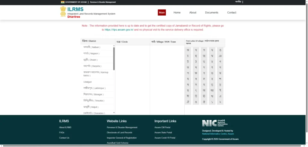
Retrieving your Jamabandi or checking owner details online is simple. Follow this step-by-step workflow:
- Step 1: Navigate to the Portal: Open a secure web browser and go to the official ILRMS homepage at ilrms.assam.gov.in. Select the Dharitree module.
- Step 2: Enter Location Parameters: Locate the correct revenue jurisdiction by selecting the following from the dropdown menus:
- District
- Revenue Circle
- Mouza (a larger revenue administrative block comprising several villages)
- Village
- Step 3: Select Search Method: You can search the live database using one of three options:
- Search by Dag Number (if you have the exact plot ID)
- Search by Patta Number (to view all plots under a specific allotment)
- Search by Pattadar Name (to look up properties owned by a specific person)
- Step 4: Use the Virtual Assamese Keyboard: If you choose to “Search by Pattadar Name”, you must type the owner’s name using Assamese script. Since standard keyboards use English, the portal provides a Virtual Assamese Keyboard on the screen. Click on the phonetic Assamese letters to spell out the name correctly.
- Step 5: Complete CAPTCHA & Download: Enter the security Captcha code shown on the screen and click “Search”. The system will retrieve the matching Record of Rights. You can view the details on your screen and click Download PDF to save an official copy of your digital Jamabandi.
Dharitree Assam Mobile App: Land Records on Your Phone
For on-the-spot property checks, the state government offers the Dharitree Mobile Application. This app is linked in real-time to the central ILRMS servers, letting you verify plot data while standing on the physical land.
Key features of the mobile app include:
- Location-Based Searches: Allows users to pick their current location and search land records by Dag, Patta, or Pattadar Name.
- Interactive Dashboard: Provides a clean, beginner-friendly interface that lets you check NOC statuses and application progresses.
- Built-in Calculators: Features integrated utility tools, including Assamese land area converters (converting local units like Bighas, Kathas, and Lessas into Hectares or Square Metres) and instant home loan calculators.
- PDF Downloads: Allows you to generate and save Jamabandi records directly to your smartphone.
Legacy Data Updation: Fixing Errors in Your Land Records
When land records are digitized, clerical mistakes can sometimes creep in, such as misspelled owner names, incorrect land area entries, or outdated remarks. These minor errors can stall property sales or block bank loan approvals. To address this, the state integrated a dedicated Legacy Data Updation module within the Mission Basundhara portal (basundhara.assam.gov.in).
Step-by-Step Online Correction Process:
- Log In: Go to the Mission Basundhara portal, navigate to the “Legacy Data Updation” section, and enter your 10-digit mobile number to log in via a secure OTP.
- Fetch Your Record: Input your District, Circle, Mouza, Village, and Dag Number to retrieve your current online record.
- Select Correction Category:
- Name Correction: For spelling errors in the Pattadar’s name or their parent/guardian’s name.
- Area Correction: If the digital land area listed online does not match your physical paper Patta.
- Remarks Updation: To clear old administrative notes or update encumbrance markers.
- Enter Correct Details: Type the corrected values in both English and Assamese script.
- Upload Documents: Upload scanned, high-quality PDF files (under 2MB) of your supporting legal proofs:
- For Name Corrections: Government-issued ID (PAN Card, Passport, Driving Licence, or MGNREGA Job Card).
- For Area Corrections: Original registered Sale Deed, physical Patta certificate, or manual Jamabandi documents.
- Submit & Track: Submit the application. The system has a standard 7-to-15 days turnaround time, making it ideal for pre-sale cleanups.
Offline Fallback: What to Do If Land Records Are Missing Online
Although the digitization of land records in Assam has progressed rapidly, some properties in un-surveyed pockets, remote revenue villages, or non-cadastral areas may not be available on the online Dharitree portal yet. In such scenarios, citizens can comfortably use traditional offline administrative channels.
1. Locating Your Nearest Circle Office
To find the physical office governing your property, download the official “Know My Circle Office” directory spreadsheet from the Directorate of Land Records website (landrevenue.assam.gov.in). This spreadsheet lists the exact contact details, addresses, and jurisdictional boundaries of every Revenue Circle across Assam.
2. Writing and Submitting a Manual Petition
If your records are missing, you can initiate a manual correction or verification:
- Draft an Application: Write a formal petition on plain paper addressed to your local Circle Officer (CO).
- Affix Court Fee Stamps: Attach court fee stamps, which typically range from Rs 8 to Rs 10, as mandated by state revenue guidelines.
- Attach Proofs: Enclose manual copies of your registered sale deeds, historical Jamabandi records, and latest land revenue payment receipts.
- Field Verification: The Circle Officer will forward your petition to the local Lot Mandal (LM) and Supervisor Kanungo (SK). The Lot Mandal will conduct a physical site survey, measure boundaries on-site, and verify your actual possession.
- Updation: Once the SK signs off on a verified field report, the Circle Officer will issue an official correction order, updating the physical field registers and syncing the correct data to the online Dharitree portal.
The Role of Mission Basundhara in Land Reforms
To completely revolutionize land governance, secure land rights for native families, and clean up the state’s registry databases, the Government of Assam launched its flagship initiative: Mission Basundhara. Spanning consecutive phases—Mission Basundhara 1.0, 2.0, and 3.0 (from 2021 to 2026)—the program has successfully streamlined public service delivery and modernized land policy.
The Core Principle of ‘Jati-Mati-Bheti’
Mission Basundhara is guided by the Assamese principle of “Jati-Mati-Bheti”, which translates to “identity, land, and homestead”. This principle establishes a direct link between formal land titles (Pattas) and the protection of the socio-cultural identity of indigenous and tribal communities, ensuring native landless families are protected from land alienation.
Exemption Rules and Relaxations Under Mission Basundhara 3.0
In previous phases, establishing eligibility for settling government land required families to provide rigorous proof of continuous occupancy. While general categories must still provide proof of residency spanning three generations (75 years), Mission Basundhara 3.0 introduced critical relaxations:
- SC, ST, OBC, Gorkhas, and Gorkha/Tea Garden communities are completely exempted from the strict 75-year residency proof rule.
- These protected groups can establish their land settlement eligibility simply by submitting a valid, government-certified caste or community certificate alongside proof of physical occupancy.
Prohibited Areas for Allotment
To protect ecologically fragile regions and preserve public resources, Mission Basundhara strictly prohibits land settlements in the following areas:
- PGR and VGR lands: Grazing reserves are strictly protected for livestock and community use and cannot be allotted for private housing or farming.
- Riverine Char Areas: Ecologically unstable sandbars and river islands (Char lands) are excluded from settlements to protect fragile eco-systems, with the permanent exception of the historic island district of Majuli.
Assam’s DILRMP Progress: State vs. National Digitization Status
Assam’s land digitization efforts are aligned with the national Digital India Land Records Modernization Programme (DILRMP), managed by the Department of Land Resources under the Ministry of Rural Development. DILRMP aims to computerize textual Record of Rights, digitize cadastral maps, and integrate spatial and registration databases country-wide.
Assam has deployed advanced, modern technologies to accelerate its DILRMP targets:
1. CORS Network (SVAMITVA Scheme)
To resolve boundary disputes and ensure pinpoint spatial accuracy, the state has established a Continuously Operating Reference Stations (CORS) network in collaboration with the Survey of India. This network enables high-precision, real-time satellite geo-positioning during land surveys.
2. Drone-Led Resurveys
In cadastral villages where old paper maps have been damaged, lost, or worn out, high-resolution aerial imagery is captured using drones (SOP for NC Villages). This imagery is used to generate highly detailed ortho-rectified maps, which are then verified on-site by community representatives and Lot Mandals before being integrated into the Bhunaksha database (SOP for NC Villages).
3. NC Village Surveys
There are hundreds of un-surveyed Non-Cadastral (NC) villages across Assam, primarily in forest tracts or riverine areas. Under the SVAMITVA scheme, the state is systematically mapping these villages using drone surveys to bring formal land rights, digital boundary frameworks, and legal protection to historically unmapped communities.
Frequently Asked Questions (FAQs)
Is a Mouza the same as a village in Assam?
No, a Mouza is not the same as a village. In Assam’s revenue administration, a Mouza represents a larger revenue block that contains a cluster of several revenue villages. When searching for your land records on Dharitree, you must select the correct Mouza before the dropdown menu will display your specific village.
What are the fees to check land records online?
Searching, viewing, and checking your land records or cadastral maps on the Dharitree and Bhunaksha portals is completely free. However, if you require a legally certified, digitally signed copy of your Jamabandi or Mutation certificate, you can apply through the Sewa Setu RTPS portal, where the official service fees range from Rs 50 to Rs 200 depending on the service.
Can out-of-state residents apply for land settlement?
No. Government land settlements initiated under successive phases of Mission Basundhara are strictly reserved for permanent, indigenous, and landless families of Assam. Applicants must meet the state’s native residency requirements and submit appropriate documentation to qualify for land allotment.