
The land tenure and revenue administration in the northeastern state of Manipur represents a fascinating study of dual administrative frameworks. In Manipur, the division between the valley and the surrounding hills is not merely geographical; it is a profound legal boundary. While the hill districts (comprising Chandel, Churachandpur, Senapati, Tamenglong, and Ukhrul) are Scheduled Areas protected under Article 371C of the Indian Constitution and governed largely by tribal customary laws, the valley districts are governed by standard statutory land administration under the Manipur Land Revenue and Land Reforms (MLR & LR) Act, 1960.
For landowners, buyers, and financial underwriters in the valley districts of Bishnupur, Imphal East, Imphal West, Thoubal, Kakching, and Jiribam, the single most critical administrative tool is the Loucha Pathap portal. Literally translating from Manipuri as “Rules Governing the Land”, Loucha Pathap is the official digital gateway for land record computerisation in the state. Developed and maintained by the National Informatics Centre (NIC) Manipur in collaboration with the state’s Department of Revenue, this online platform has shifted Manipur from a slow, opaque, colonial-era, tax-centric land registry to a modern, transparent, and legally secure e-governance ecosystem.
What is Loucha Pathap and How Does It Work?
To understand how Loucha Pathap functions today, it is essential to trace its historical and administrative evolution. The system did not emerge overnight; rather, it was built upon decades of policy shifts and overcoming early technical failures.
The System’s Genesis: From Manitron to NIC (1988–2004)
The initial attempts at computerising land records in Manipur began under the centrally sponsored, 100% grant-in-aid Computerisation of Land Records (CLR) scheme in 1988–89. In 1994, the state government commissioned Manipur Electronics Development Corporation (Manitron) to handle the data entry and system design for the valley districts. While Manitron successfully completed the initial data entry and handed over the database to the government, a lack of administrative continuity, hardware support, and integration protocols meant that the project was abandoned. Over several years of neglect, the database corrupted, the records could not be retrieved, and the state was forced to return to manual ledger-keeping.
In 2000, the state government turned to the National Informatics Centre (NIC) to restart the digitization project from scratch. NIC undertook software development, staff training, and a rigorous, structured data entry program. In June 2002, the NIC Imphal East District Centre officially began data entry using a custom-built desktop application called “Loucha Pathap”. SIO NIC Manipur and the development team designed the software engine to mirror the robust transactional and security protocols of Karnataka’s famous BHOOMI system.
On July 2, 2004, the portal was officially inaugurated by the then Chief Minister of Manipur, Shri O. Ibobi Singh, with a pilot roll-out in the Porompat Sub-Deputy Collector (SDC) Circle of Imphal East District. A comparative analysis of pre- and post-computerisation periods in Porompat demonstrated that the digital platform reduced service times and lowered administrative corruption. This success led to Porompat Circle being recognized as the top-performing division in state land revenue collection.
Transition to Web-Based e-Governance (2009–Present)
In September 2009, the Government of Manipur bifurcated the Department of Information Technology (DIT) from the erstwhile Department of Science & Technology to provide dedicated support for state-wide e-governance. Technical infrastructure was expanded with core components like the State Wide Area Network (SWAN), the State Data Centre (SDC), and integration with the National Generic Document Registration System (NGDRS). This comprehensive digital transformation earned NIC Manipur and the Department of Revenue a Silver Award for Excellence in e-Governance in February 2020 at the 23rd National Conference on e-Governance in Mumbai.
Database Design and Technical Roll-out Challenges
The state-wide roll-out of Loucha Pathap required major site preparation across administrative circles. In April 2007, the state government deposited ₹50 lakhs with National Informatics Centre Services Inc. (NICSI) to set up hardware and modify server rooms in six pilot SDC circles: Patsoi, Central (Lamphel), Thoubal, Bishnupur, Moirang, and Bashikhong.
During this expansion, a critical technical hurdle emerged in SDC Bishnupur in August 2009. SIO NIC Manipur noted that the Loucha Pathap software architecture was designed as a spatial database that indexes records strictly around the Dag Chitha (field-index) parcel structure. However, the physical data entry at SDC Bishnupur had been completed using the Jamabandi (ledger) owner-centric records. Because the software expected a parcel-first index, it refused to run on Jamabandi-only data. To resolve this mismatch, the department had to undertake a 60-day data segregation process to cross-reference the ledger entries back to the original cadastral survey maps, successfully harmonizing the database structure.
Currently, the centralized portal (louchapathap.nic.in) serves as the primary system of record for the state’s valley regions. By structuring data around the plot or parcel as the smallest administrative entity, the system ensures that every parcel is accounted for, preventing duplicates and ensuring high-speed information retrieval.
Core E-Services Available on the Loucha Pathap Portal
Loucha Pathap has centralized and automated several critical workflows that previously required physical visits to multiple revenue offices. The core electronic services available on the portal include:
- Viewing and Downloading Jamabandi, Patta, and Record of Rights (RoR): Landowners can retrieve official text extracts of their ownership records.
- e-Pay Land Tax Module: This module enables landowners across 604 registered valley villages to pay their property taxes online. Payments are secured via the State Bank of India (SBI) e-payment gateway or by scanning a dynamic UPI QR code using Paytm or any other UPI-enabled mobile application.
- NGDRS Integration: Citizens can book appointments online for document registration, calculate fees, and upload deeds, bridging the gap between land registration and revenue record updates.
- Minimum Guidance Value (MGV) Simulation: The portal provides a dynamic calculator for determining the state-notified Minimum Guidance Value of a property based on its classification, locality, and dimensions, which is crucial for calculating registration stamp duties.
- Revised Land Tax Rates: Landowners can view the latest tax rates per hectare based on land class and effective year.
- Transaction Status Tracking: Applicants can track the real-time progress of land mutation, division, and registration files.
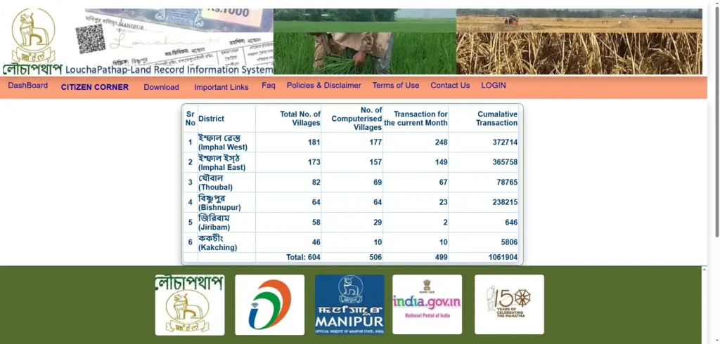
How to Check Jamabandi & Patta Online in Manipur
Retrieving your land records on the Loucha Pathap portal is designed to be a straightforward, three-minute process. Below are the precise steps for checking and exporting your records.
Step-by-Step Guide using New Patta and Dag Numbers
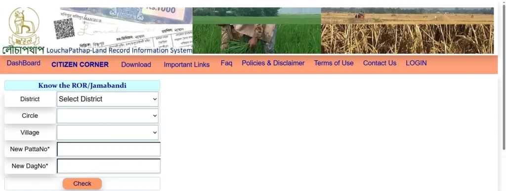
To view your Record of Rights (RoR) or Jamabandi report, ensure you have your New Patta Number and New Dag Number ready. In Manipur, the Patta Number (analogous to the Khata number) acts as a family account number representing a household’s collective landholdings. The Dag Number (analogous to the Khasra number) is the unique spatial identifier assigned to a single, undivided plot within a village.
- Visit the Portal: Go to the official Loucha Pathap website:
louchapathap.nic.in. - Locate the Service: On the homepage, find the “Know the ROR/Jamabandi” query form.
- Select Location Filters: Use the dropdown menus to select your District (e.g., Imphal West, Thoubal, Bishnupur, Imphal East, Jiribam, or Kakching), Circle, and Village.
- Enter Identifiers: Enter your New PattaNo and New DagNo in the respective columns].
- Submit the Request: Click the “Check” or “Submit” button. The portal will instantly pull up the digital Record of Rights.
- Download and Print: You can save the generated report as a PDF. For official printouts, NIC Manipur recommends using Legal Paper in Landscape orientation to ensure all tabular fields are printed clearly.
How to Search for Manipur Land Records by Name
If you do not have the Patta or Dag numbers handy, you can locate them using a name-based search on the portal.
- Navigate to the land record search page on the official website or the integrated e-Services platform.
- Choose your District, Block/Sub-division, and Village from the dropdown options.
- Select the “Search by Owner Name” or “Search by Owner/Patta Holder Name” filter.
- Enter the owner’s full name exactly as it is spelled in the official sale deed or registration documents.
- Click “Search”. The system will display all matching land records.
- If multiple results appear for a common name in the village, you can narrow down the search by cross-referencing the land area and parent patta details against your physical sale deed.
Understanding Manipur’s Legal Land Records: The Three Pillars
A clear, legally binding title to land in Manipur’s valley districts cannot be established by checking a single document. Rather, the legal taxonomy relies on three interconnected instruments prepared and maintained under the MLR & LR Act, 1960.
1. MLR Form 7: Dag Chitha (The Field Index)
The Dag Chitha is a physical field register, written in the native Manipuri language using the Bengali script. It lists every land parcel in a village in serial order based on its unique Dag number. The register serves as conclusive administrative proof of land classification. When conducting property due diligence, buyers must verify the classification field in MLR Form 7 to confirm if the plot is categorized as Private land (Settled), Government land (Khas land), a Grazing ground, or a Fishery. Purchasing or building on Khas, grazing, or fishery-classified lands is strictly illegal and subject to summary demolition.
2. MLR Form 8: Jamabandi Patta (The Ledger)
The Jamabandi is the primary revenue ledger of the state, also maintained in the Manipuri language. It lists all registered landholders alphabetically alongside details of the land parcels they hold. Under the provisions of the MLR & LR Act, 1960, the Jamabandi register serves as prima facie evidence of legal title. Maintained in duplicate, one copy of the register is kept at the Circle Office by the Recorder (Mandal/Patwari), while the duplicate is preserved at the office of the Sub-Divisional Officer (SDO) or Deputy Commissioner (DC). Key fields to verify on MLR Form 8 include the registered owner’s name, parentage, exact area share, transaction/transfer history, and land tax assessment liabilities.
3. MLR Form 16: Report for Mutation
Unlike the first two forms, MLR Form 16 (Report for Mutation) is a bilingual or English language application form. It is the formal legal petition that a property buyer must complete and submit to the local revenue administration to initiate Dakhil Kharij—the transfer and mutation of land records. This form captures critical fields, including the target village and SDC circle, the names and addresses of both recorded and applicant persons, historical Patta and Jamabandi numbers, the manner of land acquisition (e.g., Sale, Gift, or Inheritance), and the physical consideration paid.
Land Mutation (Dakhil Kharij) Workflow on Loucha Pathap
In Manipur’s real estate market, registration and mutation are entirely separate legal procedures. A common mistake among buyers is assuming that registering a sale deed at the Sub-Registrar’s office completes the transfer of ownership. Registration merely documents that a transaction occurred; the buyer is not recognized as the legal owner in the state’s revenue records until mutation is approved. Without a completed mutation, the seller’s name remains on the official Jamabandi ledger, leaving the property vulnerable to fraudulent double-sales or bank liens.
The Step-by-Step Online Mutation Application Process
To complete a mutation through the Loucha Pathap portal, follow this technical workflow:
- Verify Deed Publication: Before initiating your application, log in to the portal and confirm that your registered sale deed has been officially published. The Loucha Pathap engine features a security gate that automatically blocks a mutation request if the deed’s final publication status is incomplete.
- Download and Fill Form 16: Navigate to the “Download” tab on the Loucha Pathap homepage, select “MLR Form”, and download the APPLICATION FORM FOR PARTITION-MUTATION (MLR FORM 16). Fill in all fields, including the exact Dag and Patta numbers, location details, and applicant credentials.
- Submit Credentials: Log in to the citizen section of the portal. Upload digital copies of the completed MLR Form 16, the registered sale deed, the buyer’s Aadhaar card, and the latest property land tax receipt.
- Administrative Routing and Field Inspection: The application is routed online to the local Sub-Deputy Collector (SDC) or Sub-Divisional Officer (SDO). The officer reviews the digital files, cross-checks them against the physical village registers, and issues a public notice to invite objections. A field inspection is conducted by the local Patwari or Kanungo to verify the physical boundaries.
- Order and Code Generation: If no objections are raised, the SDC/SDO passes a formal mutation order. To prevent duplicate entries or overlapping claims, the Loucha Pathap database automatically generates a new Patta number and subdivided Dag number.
- Digital ROR Update: The system updates the live database, publishes the updated Jamabandi details online, and generates a formal, verifiable mutation certificate for the buyer.
Fee Structure for Mutation: Online vs. Offline
The Manipur government has structured mutation fees to encourage digital adoption:
- Online Portal Applications: Completely free of cost. No government fee is levied for processing digital mutation requests.
- Offline CSC Applications: If processed physically through a local Common Service Centre (CSC), a nominal service charge of ₹10 is collected from applicants who are above the poverty line (APL). For citizens classified as Below Poverty Line (BPL), the CSC service is entirely free.
Aadhaar Seeding and the 14-Digit Bhu-Aadhaar (ULPIN)
In 2026, the integration of identity databases with land records operates under a strict consent-based architecture. By linking a landowner’s Aadhaar biometric ID with their specific Dag number on Loucha Pathap, the system generates a 14-digit Unique Land Parcel Identification Number (ULPIN), commonly referred to as Bhu-Aadhaar.
This synchronization serves two major objectives:
- Anti-Fraud Security: It anchors the digital record to the verified identity of the actual owner, making it impossible for fraudsters to impersonate the landowner or execute Benami (fraudulent proxy) transactions through forged papers.
- Direct Benefit Transfer (DBT): For farmers, Aadhaar seeding is mandatory to access central and state welfare funds, such as the PM-Kisan scheme or local agricultural machinery subsidies. Government systems disburse funds exclusively to bank accounts linked to the seeded land parcel, eliminating middlemen and leakage.
Loucha Pathap ROR Mobile App & APK
To make land administration accessible on the go, the state government launched a dedicated mobile application.
Official App Details
The Loucha Pathap – ROR APP (currently operating on stable Version 1.0.0) was developed by NIC eGov Mobile Apps specifically for Android devices. The lightweight app (approx. 3.42 MB) can be downloaded via Google Play or as an APK file.
Key Mobile Capabilities
- Instant Jamabandi Retrieval: Users can view and download their Jamabandi/RoR reports in PDF format directly to their smartphones by entering the district, SDC circle, village, Dag, and Patta numbers.
- Custom QR and Barcode Reader: The app features an integrated scanning tool. Litigants, bank loan officers, and registration clerks can instantly verify the authenticity of a printed land document by scanning its unique QR code, which fetches the live record directly from the government servers, preventing the use of fake paper certificates.
- Alternative Applications: Citizens can also use “Manipur Bhumi”, a prominent third-party mobile application developed by mm.marsman, which provides integrated land area calculation tools, registration calculators, and transaction trackers.
Legal Barriers & Geographic Gaps to Keep in Mind
While Loucha Pathap represents a major step forward, buyers and developers must navigate strict constitutional, geographic, and administrative barriers unique to Manipur.
Valley Districts vs. Unsurveyed Hill Districts
The single most critical geographic gap is the dual land tenure system of the state. The statutory provisions of the MLR & LR Act, 1960—and by extension, the Loucha Pathap digital database—apply only to the valley revenue districts (Bishnupur, Imphal East, Imphal West, Thoubal, Kakching, and Jiribam).
The hill districts (Chandel, Churachandpur, Senapati, Tamenglong, and Ukhrul) are Scheduled Areas protected by Article 371C of the Indian Constitution. Under this constitutional protection, land in hill areas is governed by tribal customary laws and managed by local Village Authorities or Customary Chiefs. Because these vast hill regions have not undergone modern cadastral mapping or systematic land surveys, hill district land records do not exist on the Loucha Pathap portal. Buyers trying to verify hill properties must manually coordinate with local Autonomous District Councils or the relevant Deputy Commissioner’s office, as online verification is unavailable.
The Inner Line Permit (ILP) and Valley Buyer Restrictions
Even within the surveyed valley districts, land transactions are subject to rigorous regulatory barriers designed to protect indigenous interests.
- The ILP Fallacy: Non-residents of Manipur must obtain an Inner Line Permit (ILP) to legally enter the state. The standard Temporary Permit (Form C) costs ₹100 and is valid for only 30 days. Many out-of-state buyers wrongly assume that holding a valid ILP grants them the right to purchase property. The ILP is strictly a travel document and confers no land ownership or registration rights.
- The September 2025 Notification: Under strict state-level directives issued in September 2025, deed registrations transferring land from an indigenous person to a non-indigenous outsider are completely blocked. The only carve-out is for permanent residents of Manipur, and even they must obtain explicit, written prior approval from the local Deputy Commissioner (DC) and a specialized state-level review committee before a sale deed can be legally registered at the Sub-Registrar’s office.
Common Pitfalls and Troubleshooting
Real estate transactions in Manipur carry high litigation risks if digital checks are skipped. Below are the most common traps and how to resolve them.
1. The Broken Chain of Title (Unmutated Records)
A frequent pitfall is purchasing land based on an unmutated title. This occurs when a past buyer registered a sale deed but never filed the follow-up mutation on Loucha Pathap. Consequently, the original seller’s name (or a deceased ancestor’s name) remains on the live Jamabandi ledger. If you purchase land with a broken chain of title, the Sub-Registrar will refuse registration, and you will be forced to trace past transactions through the slow, expensive revenue courts to resolve the title defect.
- The Fix: Insist that the seller complete all pending mutations so their name appears correctly on the digital Jamabandi before you sign any agreement or pay an advance.
2. Boundary and Cadastral Survey Mismatches
Because systematic land resurveys in many parts of Manipur have not been conducted in decades, physical plot boundaries on the ground often do not align with the digital records in the Dag Chitha.
- The Fix: Never buy land relying solely on the digital map. Engage a licensed surveyor to physically measure the plot boundaries on-site. Any discrepancy between the physical layout and the Dag Chitha must be corrected by submitting a rectification petition to the Directorate of Settlement and Land Records in Lamphelpat, Imphal, which typically resolves boundary disputes within two weeks.
3. Server Lag and Peak-Hour Loading
Due to heavy concurrent usage by bank officers and Common Service Centres, the Loucha Pathap portal can experience slow loading times or database timeouts.
- The Fix: If you encounter portal lag, perform your searches during off-peak hours (early morning or late evening). Ensure your browser is updated to Google Chrome 7.x or higher, and set your screen resolution to 1600 x 900 for optimal rendering of the spatial maps.
Frequently Asked Questions (FAQs)
Is there a fee to check and download land records on Loucha Pathap?
No. Searching, viewing, and downloading basic Jamabandi, Patta, or Record of Rights (RoR) reports from the official portal is completely free of cost for all citizens.
Why is my online land mutation request blocked?
The system features an automated safeguard that blocks mutation submissions if the registered sale deed’s final publication has not yet been processed and updated in the Loucha Pathap database. You must wait for final deed publication before applying.
Can someone from outside Manipur buy land in the state?
No, not straightforwardly. Since the September 2025 state notification, land transfers from indigenous persons to non-indigenous outsiders are legally blocked. Only permanent residents of Manipur are eligible to apply, and they must undergo a rigorous review by the Deputy Commissioner and a state-level committee before registration.
How is land measured in Manipur?
While the Loucha Pathap database lists areas in metric standard hectares, local transactions and historical manual registers frequently use traditional land measurement units, specifically Bigha, Sangam, and Katha.
Who should I contact for discrepancies in my land records?
If you detect typographical errors or administrative discrepancies in your digital records, you should submit a formal rectification petition with supporting documents to the local revenue office.
Sourced Reference Guidelines
This comprehensive guide is strictly grounded in the official administrative records and notifications of the Government of Manipur, including the Manipur Land Revenue and Land Reforms Act, 1960, the Directorate of Settlement and Land Records, and the integrated National Generic Document Registration System (NGDRS).