If you are planning to buy land, sell a family plot, or verify property ownership in Agartala or any other corner of Tripura, you already know that land transactions can feel like navigating a maze. For decades, the process of checking land ownership, tracing legacy boundaries, and verifying title deeds required endless physical trips to the local tehsil or sub-divisional office.
Fortunately, the digital age has completely transformed how land administration operates in Northeast India. Under the Digital India Land Records Modernisation Programme (DILRMP)—which succeeded the older National Land Records Modernization Programme (NLRMP)—the Government of Tripura launched its official single-window solution: the eJami Tripura Portal (accessible at jami.tripura.gov.in).
What is eJami Tripura? Modernizing Northeast Land Records
At its core, eJami Tripura is a web-based, single-window database management application built to handle the state’s entire land record lifecycle. Developed in partnership with the National Informatics Centre (NIC) Tripura and the state’s Directorate of Land Records and Settlement (DLRS) under the Revenue Department, the computerized framework officially commenced operations on September 1, 2011.
The primary goal of eJami is to enhance transparency, streamline bureaucratic workflows, and eliminate real estate frauds and unauthorized modifications. Rather than relying on physical paper registers that are easily lost, damaged, or altered, eJami stores the state’s textual and spatial data in secure, computerized centers.
The Transition from NLRMP to DILRMP
Historically, land records in Tripura were maintained through localized, manual ledgers. Under the centrally funded NLRMP—now upgraded to the Digital India Land Records Modernisation Programme (DILRMP)—the state undertook a massive computerized modernization drive. Today, over 99% of Records of Rights (RoRs) have been digitized, allowing immediate online access to millions of landholders across the state.
The Dual-Platform Model: Frontend Citizen Portal vs. Secure Backend
To maintain maximum data integrity while remaining highly accessible to the public, eJami operates on a dual-platform model.
- The Citizen-Centric Frontend: Accessible publicly at
jami.tripura.gov.in, this interface is open to any citizen. It allows the public to run query-based searches, check mutation status, download reference maps, and perform unit conversions completely free of charge and without requiring mandatory registration for basic views. - The Secure Official Backend: This restricted platform is designed strictly for revenue officials. Modifying, updating, or deleting any land record requires biometric logging, multi-factor authentication (MFA), and secure official credentials. This ensures a clear audit trail for every administrative change.
Security Integrity: Biometric MFA and Maker-Checker-Approver Workflow
To prevent internal tampering or collusive fraud, eJami enforces a strict Maker-Checker-Approver workflow.
- The Maker: A lower-level revenue clerk or data operator initiates a record change (such as entering transaction details after a land sale).
- The Checker: A superior officer verifies the entered details against the physical sale deeds and coordinate-based survey data.
- The Approver: The sub-divisional revenue officer officially approves and signs off on the entry. No single individual has the administrative power to unilaterally alter the database, protecting landowners from unauthorized title changes.
Khatian vs. Dag: Understanding Tripura Land Record Terms
If you want to check Khatian online, you must first master the unique vocabulary of Tripura’s revenue department. Like many Eastern Indian states with a Bengali administrative legacy, Tripura uses terms that can confuse first-time buyers. Let’s break down the two most critical spatial and textual identifiers:
Khatian: The Owner’s Revenue Account
A Khatian (also referred to as the Record of Rights or RoR) is your primary proof of land ownership. Think of a Khatian as a financial bank account, but instead of tracking cash deposits, it groups all the land parcels owned by a specific person (or a group of joint owners) within a single revenue village (Mouza).
Your digitized Khatian displays:
- Your unique Khatian account number.
- The registered owner’s name and parentage (referred to as the Raiyat or Khatedaar).
- A list of all individual plots (Dag numbers) linked to your name.
- The exact area of each plot and the total holding acreage.
- The land classification (such as Tilla tops, Lunga valley, agricultural, homestead, pond, or commercial).
- The nature of possession and superior interests (like occupancy raiyat or government lessee).
- A dedicated column (Column 16) capturing real-time transaction updates, registration deeds, and active mutation histories.
Dag Number: The Permanent Spatial Plot Identifier
While your Khatian number can change if you split, sell, or mutate your land, the Dag number (the equivalent of a Khasra number in Northern India) is a permanent spatial identifier for a specific geographic parcel.
When a village is surveyed, it is divided into individual physical plots on a cadastral map. Each plot is assigned a unique Dag number. Therefore:
- A Khatian tells you who owns the land.
- A Dag tells you where the physical parcel is, what its boundaries look like, and its exact shape.
Sabek (Old) vs. Hal (New) Plot References
During your search, you will frequently see references to Sabek and Hal plot numbers.
- Sabek refers to the old, legacy plot numbers recorded during pre-colonial or historical colonial surveys.
- Hal refers to the new, revised plot numbers established during modern survey, settlement, and digitization operations. Always ensure your sale deed and digital records clearly map both references. If there is a mismatch between the Sabek and Hal numbers in the seller’s documentation, you must halt the transaction immediately until the discrepancy is rectified at the Sub-Divisional Magistrate (SDM) or Circle office.
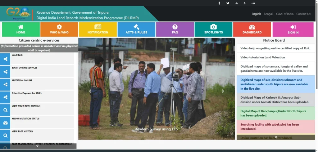
Step-by-Step Guide: How to Search Jami Tripura Land Records Online
Let’s walk through the actual steps of pulling a digital record of rights from the official portal.
Method 1: Land Record Search by Name in Tripura (Raiyat/Owner Name)
If you do not have the specific Khatian or Dag numbers, you can search the database using the owner’s name. This is highly useful for preliminary due diligence.
- Visit the Portal: Open your browser and navigate to jami.tripura.gov.in.
- Select Citizen Services: On the homepage menu, click on Get Online ROR/Khatian or View Your ROR/Khatian.
- Specify Location Hierarchy: Select your location step-by-step from the dropdown menus:
- District: Choose from the 8 districts (e.g., West Tripura, South Tripura, Gomati, etc.).
- Sub-Division: Lower administrative tier below the district.
- Tehsil: Local revenue circle office.
- Mouja: The specific revenue village.
- Select Search Criteria: Choose the radio button for Search by Owner Name (Raiyat Name).
- Enter Owner Name: Type the owner’s name exactly as it appears on their legal deeds. Pro Tip: Many older records are stored in Bengali script. If the English spelling returns no results, try utilizing the Bengali search interface or check spelling variations.
- Complete Captcha & Search: Click Search or Display. The portal will display matching records. Click on your target account to view, download, or print the digital reference copy.
Method 2: Search by Khatian Number
If you already know your Khatian account number, the search takes less than a minute.
- Navigate to the Khatian/Plot based search page under Citizen services.
- Select your District, Sub-Division, Revenue Circle, Tehsil, and Mouja.
- Select Khatian Number as your search filter and type in the numeric ID.
- Click Display. The system will instantly retrieve the Record of Rights showing all plots linked under that specific account.
Method 3: Search by Dag (Plot) Number
If you want to verify a specific parcel of land before signing an agreement, running a plot-based search is essential.
- On the View ROR search screen, select the location hierarchy down to the Mouja level.
- Choose the search filter for Plot Number (Dag Number).
- Specify whether you are entering a Hal (New) or Sabek (Old) plot number.
- Input the plot number and execute the search. The portal will show you the exact Khatian account it is currently linked to, the registered owner’s share, and the recorded land area.
Method 4: Tracking Land Records via Rapat, Vaseeka, or Mutation Numbers
If you are tracking an ongoing property transaction, eJami provides alternative tracking parameters:
- Search by Rapat Number: A Rapat number serves as an official transactional record identifier. Log in, choose your location, select Search by Rapat, and input the ID to view transaction details.
- Search by Vaseeka Number: A Vaseeka number refers to the deed registration number. Under the citizen services tab, click Know Mutation Status, enter the location details, and input your Vaseeka or Mutation Request Number to view real-time progress.
Online Mutation (Namjari) Services & Auto-Trigger Updates
Mutation (also locally known as Namjari or Dakhil-Kharij) is the single most critical step in property acquisition. While registering a sale deed at the Sub-Registrar Office (SRO) records your transaction, mutation officially transfers the title in the revenue registers. Until your name is mutated into the Khatian, you are not recognized as the legal taxpayer, you cannot raise institutional home loans, and you cannot sell the land in the future.
How to Check e-Jami Mutation Status Tracking Online
If you have applied for a mutation, you can easily track its progress online without paying any bribe or visiting the circle office.
- Go to eJami: Visit jami.tripura.gov.in and scroll down to the Citizen Centric Services menu on the left pane.
- Select Know Mutation Status: Click on Know Mutation Status.
- Enter Location Parameters: Fill in the dropdowns for District, Sub-Division, Revenue Circle, Tehsil, and Mouja.
- Enter your Mutation Report (MR) Number: This is the unique transaction tracking number assigned to your application when you applied for mutation.
- View Status: Click Search to see the real-time status of your application (e.g., Pending Verification, Field Survey Scheduled, Approved, or Rejected).
The 2026 Shift: TORS Integration and Auto-Triggered Mutations
Historically, property buyers had to complete a two-step process: first, register the sale deed at the SRO, and second, submit a separate physical mutation application at the Circle revenue office. This dual process often led to major delays and transaction backlogs.
To solve this, the Revenue Department completed a groundbreaking programmatic upgrade. Today, eJami is programmatically integrated with the Tripura Online Registration System (TORS).
- How it works: When a deed is registered at any of the 23 Sub-Registrar Offices online, the TORS system automatically queries the eJami database to verify the seller’s Khatian, plot dimensions, and coordinates.
- The Auto-Trigger: Once the deed is registered, TORS pushes a programmatic trigger to the eJami backend to initiate an automatic mutation request. The transaction status is reflected in Column 16 of the digital Record of Rights, creating an automated link that alerts future buyers and prevents fraudulent double-selling of the same plot.
Paying Registration Fees and Mutation Charges via eGRAS & eStamps
eJami and TORS have also been integrated with the State Receipt Portal (eGRAS) and the Stock Holding Corporation of India Limited (SHCIL) e-Stamping network.
- Circle Rates: Citizens can calculate exact registration fees and compounding stamp duties online based on local Guideline Rates (DM rates).
- Online Stamp defacement: e-Stamps are paid via integrated SBI-ePay payment gateways, verified for concurrency, consumed, and instantly defaced by downstream applications to prevent reuse.
- Mutation Fee: The online state mutation share is programmatically charged (approximately INR 25), which is processed directly online.
Navigating Tripura’s Administrative Hierarchy
To successfully retrieve online land records or check mutation status, you must understand how the state’s administrative divisions are mapped. If you select the wrong sub-division or mouja, the system will return an “empty result” error, even if your plot is legally registered.
The Five-Tier Governance System
Tripura’s land administration is structured into five distinct levels. Here is the operational scale as of 2026:
- Districts (8 Districts): The highest administrative tier. The District Magistrate and Collector acts as the appellate authority.
- Sub-Divisions (23 Sub-Divisions): This is the tier responsible for compiling regional cadastral registers, resolving title disputes, and officially approving mutation requests.
- Revenue Circles (5 Circles / 45 Local Offices): Oversees physical field surveys, coordinate validations, and manages the computerized distribution of digitally signed documents. Note: While the central eJami registry tracks 5 macro-circles, the state revenue unit operates across 47 localized administrative circles for field tasks.
- Tehsils (39 Tehsils): The actual, physical ground office responsible for record-keeping and local dispute hearings. If you need a certified physical copy of your ROR (Form-B), you apply at your local Tehsil office.
- Mouja (112 Moujas): The smallest base geographic unit. A Mouja represents a revenue village. This is the baseline filter used for cadastral mapping and Bhu-Naksha boundaries.
Unlocking Traditional Land Units in Tripura (The Math Trap)
One of the biggest financial risks of buying property in Northeast India is navigating localized, traditional land units. Unlike other states that transact uniformly in square feet, square meters, or standard acres, rural sellers in Tripura still quote prices using legacy metrics.
Local Measurement Units: Kani, Ganda, Kranta, Kara, and Dhur
Traditional Tripura land records utilize a cascading mathematical structure:
- Acre and Hectare: Used in modern digitized databases.
- Kani: The primary traditional area unit used in local village circles.
- Ganda: A legacy sub-unit.
- Kranta: Commonly used during inheritance partitions to divide shares.
- Kara: Used for precise boundary demarcation.
- Dhur: Used for small residential plots and micro-holdings.
The Dhur Conversion Discrepancy: Database vs. Rural Surveys
Here is a major transactional warning: The “Dhur Trap.” In Tripura’s official digitized eJami database, the calculation standards are normalized to standard imperial units.
- The Database Standard: For automated computational purposes, the portal’s built-in “Plot Unit Conversion” tool standardizes 1 Dhur at exactly 3.6 square feet.
- The Rural Survey Discrepancy: In legacy rural survey papers and pre-colonial local surveys, local surveyors (Amins) and village sellers often calculate land using a traditional factor of 68.06 square feet per Dhur.
If you purchase a plot listed as “100 Dhurs” from a rural seller assuming the traditional 68.06 sq. ft. rate (equivalent to 6,806 sq. ft. of ground land) but the digitized eJami database records it under the standard 3.6 sq. ft. baseline (evaluating to just 360 sq. ft.), you face an immense, irreversible financial shortfall and a major title dispute.
Always run your manual checks utilizing the eJami conversion calculator at the bottom of the homepage before paying any advance or token money!
Compliance Vulnerabilities and Transactional Risks
While digitalization has made routine queries accessible and free, checking land records online is only your first screening layer. State compliance audits and legal reports highlight major systemic loopholes that property buyers must check manually:
Section 187 Protections: Scheduled Tribe (ST) Land Transfer Restrictions
To protect the indigenous tribal population from exploitation, the Tripura Land Revenue and Land Reforms (TLR&LR) Act, 1960 features a powerful statutory shield under Section 187.
- The Rule: Any transfer of land owned by a member of a Scheduled Tribe (ST) to a non-tribal buyer is strictly legally void unless prior, explicit written permission is obtained from the District Collector.
- The Penalty: If you purchase ST-held land without Collector approval, the transaction is illegal, the sub-registrar will reject the registration, your mutation will be denied, and you can face immediate eviction and financial forfeiture.
- Before putting any money down, always check the Khatian class to confirm the tribal status of the seller.
TTAADC Boundaries and Hilly Terrain Regulations
Roughly two-thirds of Tripura’s geographical terrain falls under the administrative jurisdiction of the Tripura Tribal Areas Autonomous District Council (TTAADC).
- TTAADC areas are governed under the Sixth Schedule of the Indian Constitution, adding layers of local council approvals for land usage, transfers, and agricultural conversions.
- If your target property falls within a hilly district (like Dhalai, parts of Gomati, or Khowai), you must physically verify the plot’s TTAADC administrative status at the local revenue office.
The 30-to-60-Day Portal Synchronization Lag
Do not rely blindly on a clean screenshot of the eJami portal.
- The Synchronization Backlog: Online records on the public eJami portal typically lag behind physical registries by 30 to 60 days.
- The Danger: A seller who mutated or mortgaged their land three weeks ago might still appear as the clear, dispute-free owner on the public website.
- For high-value transactions, always visit the local District Commissioner (DC) office to verify the physical Khatian register, which is updated in real-time.
Unresolved Legal Heir Mutations
If a registered landowner dies and their family members fail to complete the mutation of inheritance, the public database will continue to list the deceased individual’s name.
- If you sign a sale agreement with the children or heirs without a formalized mutation, the transaction is legally weak.
- Lenders will reject your home loan applications, and registration offices will block the transfer.
- Ensure the family completes the legal heir mutation before you finalize your transaction.
The Aadhaar and Biometric Seeding Deficit (CAG Audit Insights)
A major compliance gap highlighted by the Comptroller and Auditor General (CAG) of India is the state’s identity seeding deficit.
- Audit Findings: Compliance audits revealed a 0% (Nil) rate of Aadhaar or biometric seeding within the digitized Record of Rights (RoRs) and cadastral databases.
- The Consequence: Because digitized land records lack verified national biometric links, it is extremely difficult for automated systems to definitively verify the seller’s physical identity without manual, block-level physical document reviews.
- Verify the seller’s physical Aadhaar, PAN card, and original deeds side-by-step to prevent identity theft and fraudulent impersonation.
Programmatic Inter-System Integrations of eJami
To build an end-to-end digital ecosystem, the Tripura state government has executed several successful programmatic links between eJami and external systems:
NGDRS Integration: 100% SRO Coverage in Tripura
Under the DILRMP framework, Tripura successfully migrated to the National Generic Document Registration System (NGDRS).
- Today, 100% of the state’s 23 Sub-Registrar Offices (SROs) are fully integrated with the centralized eJami land records database.
- This seamless API integration allows SROs to perform real-time checks on the owner’s name, plot coordinates, and tax liabilities before approving any registration deed.
PDS Crop Procurement API: Direct Benefit Transfers for Paddy Farmers
Beyond real estate, eJami is a powerful tool for agricultural governance.
- Tripura’s Paddy Procurement Portal is programmatically linked with the eJami database via secure APIs.
- Direct Benefit Transfer (DBT): When a farmer brings their crop to a minimum support price (MSP) procurement center, the system cross-references their Ration Card and digitized Khatian.
- The system verifies that the quantity of grain sold matches the estimated yield of their registered acreage, eliminating middlemen and routing funds directly to the actual cultivator’s bank account.
Strategic Recommendations for Future Institutional Reforms
While the eJami platform has successfully digitized the state’s land records, the transition to an automated, secure land administration system requires addressing several key technical and administrative challenges:
- Mandatory Aadhaar Seeding: To resolve the identity verification issues highlighted in CAG audits, the state should implement consent-based Aadhaar seeding within the digital RoR database. This is critical to reducing backlogs in welfare program verifications, minimizing agricultural program fraud, and securing transactions against identity theft.
- Establish Real-Time Database Synchronization: The update lag between sub-divisional approvals and the public eJami portal should be minimized through automated data synchronization. Transitioning from a batch-update system to a real-time ledger will protect buyers from transactions initiated on outdated online information.
- Incorporate Automated Geo-Fenced Alerts for Restricted Lands: The eJami search interface should feature automated alerts for properties subject to transfer restrictions. Specifically, plots falling within protected tribal belts under Section 187 of the TLR&LR Act or under litigation in revenue courts should be clearly flagged online to prevent invalid transactions.
- Enhance Local Language Access and Translations: While English search options are available, many foundational records are maintained in Bengali script. Integrating real-time translation and transliteration tools within the eJami portal will make land records more accessible to a broader range of users, reducing reliance on third-party intermediaries.
Frequently Asked Questions (FAQs)
What is Jami Tripura, and is it free to use?
Yes, Jami Tripura (eJami) is the official online land records portal managed by the Revenue Department, Government of Tripura. Viewing basic land records, tracking mutation status, and checking maps is completely free of charge and does not require registration.
Can I buy tribal land (ST land) in Tripura?
Under Section 187 of the TLR&LR Act, 1960, transferring tribal land to a non-tribal person is legally void unless prior, explicit written permission is obtained from the District Collector. Buying restricted ST land without this consent is illegal and carries severe financial risks.
Why is my recent land mutation not showing up on the online portal?
Digital records on the eJami portal typically experience a synchronization lag of 30 to 60 days. While your mutation might be approved physically at the sub-divisional level, it takes time to reflect online. Always verify the current physical register at the local District Commissioner (DC) office before finalyzing any purchase.
How can I get a certified copy of my land map or ROR for legal use?
Online printouts from the portal are suitable for reference and preliminary verification only. For legal proceedings, property registrations, or home loan approvals, you must obtain an officially signed certified copy (Nakal or Form-B) from your local Revenue circle or Tehsil office by submitting your documents and paying nominal court fees.