Land in the picturesque state of Nagaland represents far more than a physical space for agriculture or residential development; it is the absolute cornerstone of tribal identity, cultural heritage, and socio-economic survival. Navigating the property market or trying to understand Nagaland land records requires adjusting to a unique legal framework. Unlike the rest of India, where the state operates under the sovereign doctrine of eminent domain—registering citizens merely as revenue tenants or landholders—Nagaland shares sovereign authority over its territory directly with traditional tribal communities, clans, and families.
This comprehensive guide breaks down how to check, verify, and manage your property records in Nagaland. Whether you are a local landholder looking to update your Record of Rights (RoR) or a prospective buyer conducting crucial transaction due diligence, this master manual provides the essential legal pathways, digital portals, and customary protocols required to secure your title.
Understanding Nagaland’s Dual Land Governance System
Nagaland operates under a unique dual-layered system of land governance. On one side stands the statutory state administration, which manages government-acquired properties, municipal zones, and administrative towns. On the other side sits a deeply entrenched system of customary tribal authority, which regulates the vast majority of the state’s geographical area.
The Constitutional Shield: Article 371A
At the foundation of Nagaland’s unique property landscape is Article 371A of the Constitution of India. Inserted as a partial fulfillment of the historic 16-Point Agreement of 1960 (which facilitated the creation of Nagaland as a state in 1963), this constitutional provision acts as an unyielding shield. Under Article 371A, no Act of the Indian Parliament can apply to Nagaland if it interferes with Naga religious or social practices, customary laws and procedures, the administration of civil and criminal justice based on those customary laws, or the ownership and transfer of land and its resources. Parliamentary acts in these domains can only be implemented if the Nagaland Legislative Assembly passes a formal resolution by a majority vote to adopt them.
Statutory vs. Customary Ownership (88.30% vs. 11.70%)
This constitutional status splits the state’s lands into two highly unequal categories:
- Customary & Communal Lands (88.30%): Approximately 88.30% of Nagaland’s total geographic area is owned and regulated by tribal communities, village councils, clans, and individual private indigenous owners under traditional customs. The state government exerts zero administrative control over these customary territories unless the land is explicitly acquired through negotiated voluntary agreements.
- State-Controlled Lands (11.70%): The state government controls a mere 11.70% of Nagaland’s territory. This minor fraction is restricted to protected forest reserves, municipal boundaries (such as the Dimapur Mouza), and lands explicitly acquired for state infrastructure, departments, or administrative headquarters.
Patriarchal Customary Inheritance and Gender Gaps
Although traditional systems offer local autonomy, they also perpetuate significant gender disparities in land ownership. Naga customary laws are strictly patriarchal. Across nearly all recognized tribes, inheritance and ancestral property rights are transmitted strictly along the male lineage.
For example, in the traditional customs of the Ao Naga tribe, ancestral property (senmang) is inherited as a joint tenancy only by agnatic male descendants (senmangers). If a landowner dies without leaving a male heir, the ancestral property re-enters the clan pool, reverting to brothers, uncles, or the nearest agnatic male relatives. The deceased’s widow or daughters are prohibited from inheriting ancestral land. While women may acquire private property through direct purchase, or receive small non-ancestral plots as affectionate gifts from parents during their lifetime, they face systematic exclusion from formal inheritance.
To challenge these deep gender gaps, community organizations like the Sisterhood Network have led Feminist Participatory Action Research (FPAR) programs in rural areas like Beisumpuikam village (Peren district). These initiatives empower indigenous women to advocate for land ownership rights and a more equitable voice in Village Councils, which serve as the primary custodians of customary land distribution and administrative policy.
How to Check Nagaland Land Records Online
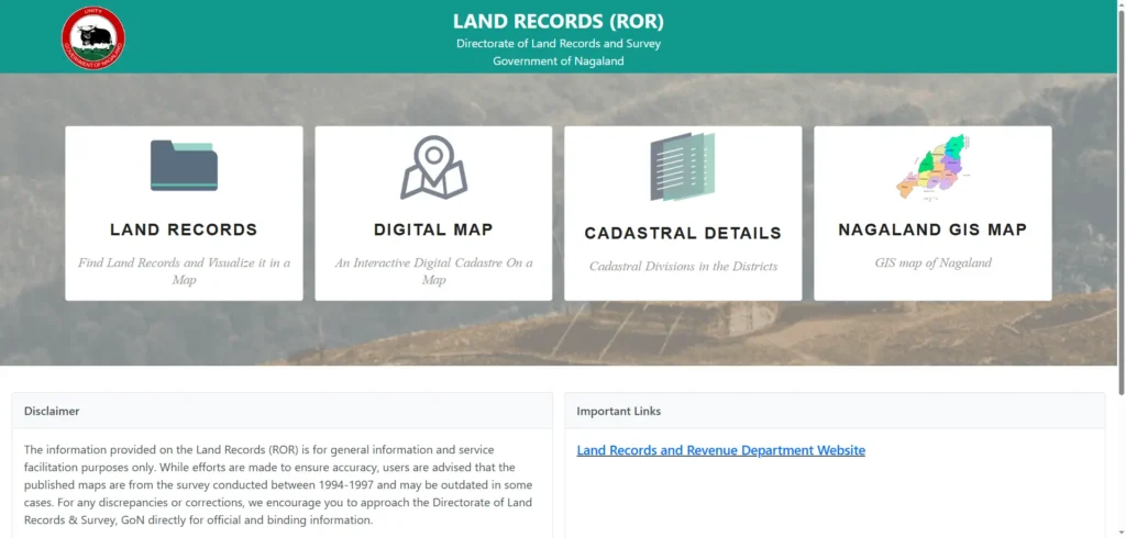
While the state remains heavily reliant on physical, manual ledgers due to its unique constitutional protections, the government is gradually rolling out web-based tracking systems under the DILRMP scheme.
Navigating Official State Portals
The Directorate of Land Records and Survey (DLRS), originally established in Kohima in 1973 and shifted to Dimapur in 1975, is the primary department responsible for formal mapping and revenue records. To access state-level online services, utilize the following official resources:
- DLRS Portal: The official administrative website is dlrs.nagaland.gov.in. This site provides public notifications, downloadable application forms for land registration, patta applications, and survey details.
- ROR Database: To access the digital Record of Rights (RoR) database, navigate to lrsror.nagaland.gov.in.
Step-by-Step Online Search Process
For properties located within municipal limits, government pockets, or the Dimapur Mouza, follow these steps to verify preliminary details online:
- Step 1: Open your web browser and go to the official portal at lrsror.nagaland.gov.in.
- Step 2: Locate the Citizen Services tab and select the Land Records (RoR) option.
- Step 3: Enter your specific query fields: select the correct district, sub-division (circle), village, and enter the unique Survey/Plot Number. Ensure spellings match the physical sale deed exactly, as minor spelling variations will result in blank queries.
- Step 4: Review the populated Record of Rights ledger, which displays the recorded owner’s name, land classification, precise area dimensions, and documented liabilities.
- Step 5: Download the document or save a high-resolution screenshot. Keep this printout for direct physical verification at the DC office.
Gaps in the Online Database (Why You Must Not Rely Solely on Screenshots)
Prospective buyers must exercise extreme caution. The online Record of Rights (RoR) database is not updated in real-time. There are significant database lag issues where a land transaction has been registered and executed, but the official mutation entry has not yet been pushed to the live portal. A screenshot showing a clean record on the portal is not legally binding. Always obtain a certified, physical copy directly from the DC office before committing any funds.
Third-Party Mobile Tools: Nagaland – Land Info & Bhu Maap
Several third-party mobile applications, such as “Nagaland – Land Info” (by Marsman) and “Bhu Maap”, exist on the Google Play Store to simplify access to land information. These applications act as mobile-friendly wrappers that link directly to official state servers, providing unit calculators and preliminary mapping details. However, they contain clear disclaimers stating they do not represent government entities and advise users to perform final legal verifications in person at official state departments.
How to Verify Nagaland Land Records Offline
Because of constitutional boundaries and the incomplete status of state-wide digitization, offline verification remains the primary, legally binding route for property transactions in Nagaland.
Getting Certified Copies from the DC or Circle Office
To retrieve a certified, signed, and stamped copy of an official Record of Rights (RoR) extract or land patta, follow this procedure:
- Visit the Correct Office: Travel directly to the Circle Office or the Deputy Commissioner’s (DC) Office in the district where the property is located. Land records are strictly localized and cannot be pulled across districts.
- Submit a Written Application: Collect the standardized land record request form from the designated counter. If you are verifying multiple distinct land parcels, you must submit separate applications for each plot.
- Provide Proof of Interest: Attach copies of documents showing your legal connection to the land (e.g., a signed sale agreement, inheritance certificate, or a registered Power of Attorney).
- Pay Applicable Fees: Deposit the official copying and service fees at the counter and secure a dated payment receipt. This receipt is your only valid tracking reference.
- Official Verification: The revenue clerk will cross-match your application details against the physical, manual registers. Once verified, a printed extract will be sent to the authorized officer for signature. This officially signed hard copy is the only version accepted in courts of law and commercial banking applications.
Checklist of Required Documents
To ensure a smooth offline verification process, bring photocopies of the following essential documents:
| Category | Recommended Documents to Bring |
|---|---|
| Proof of Identity | Aadhaar Card, PAN Card, Indian Passport, or Permanent Driving License |
| Proof of Address | Photocopied photo ration card, active utility/electricity bills, or voter ID card |
| Property Documents | Original registered Sale Deed, previous Patta allotment papers, or maternal inheritance deeds |
| Revenue Receipts | Latest physical Treasury Receipt, Khajana (revenue) receipt, or municipal property tax clear receipts |
Essential Fields to Verify on a Certified RoR Extract
When you receive your physical certified copy, carefully inspect the following key fields to ensure the title is clean:
- Owner Name: Must match the seller’s official identification papers exactly, without spelling discrepancies.
- Survey / Plot Number: Must match both the village cadastral map and the boundaries described in your sale agreement.
- Classification: Confirm the plot is classified as residential or agricultural. If the land classification field reads “Government Pocket” or “Protected Forest,” halt the transaction immediately, as private sales of such land are restricted.
- Recorded Area: Cross-check the measured area in acres, bighas, or hectares against the seller’s claim.
- Liabilities Column: Ensure the liabilities section is blank. Any outstanding government dues, active court orders, or bank mortgages recorded here will automatically transfer to the new buyer.
Customary Verification: The Village Council Layer
If the property you are purchasing is located within rural, tribal, or clan-held areas outside municipal town limits, state records will be completely blank. In these zones, the Village Council Land Record is the highest proof of property ownership.
Why the Village Council Record Holds More Weight in Rural Areas
The state’s DLRS only maintains registers for approximately 11.70% of the state. For the remaining 88.30% of tribal lands, the Village Council acts as the sole administrative custodian of property transfers, allocation, and customary boundaries. Under Article 371A, a formal statutory sale deed registered at a state sub-registrar office has zero practical validity in a tribal village if the local village council does not recognize the transaction.
Traditional governance models vary significantly across tribal lines, directly impacting land ownership and dispute resolution:
- Ao Naga Tribe: Governed by the democratic Putu Menden (Village Council). The council regulates common clan lands and strictly decides which rotational forest sites are cleared for jhum (shifting) cultivation each year.
- Sumi Naga Tribe: Governed by a traditional Akukao (Village Chief) system. The Akukao owns and controls up to 60% of the village land, acting as a paternalistic guardian who allocates plots to landless villagers in exchange for a portion of their annual crop yield.
- Konyak Naga Tribe: Governed by the hereditary Ang (King), who serves as the supreme head of local governance, managing ancestral lands, village forests, and local resources.
- Angami Naga Tribe: Governed by a highly democratic system of elders. Land is almost entirely held under individual private ownership rather than clan or village reserves, making transactions highly localized.
Step-by-Step Customary Verification Protocol
To verify a customary title, you must follow this strict localized protocol:
- Step 1: Identify the recognized Village Council for the area. Under the Nagaland Village and Tribal Councils Act of 1978, each established village has a statutory council composed of members chosen according to local customs.
- Step 2: Submit a written request to the Village Council Chairman or Secretary. Ask the council to verify the seller’s traditional ownership history (ideally tracing back through at least two previous transfers) and confirm that no inheritance or boundary dispute is active.
- Step 3: Request a physical boundary walk. Because rural lands lack formal survey numbers, borders are recorded by natural landmarks such as specific trees, ridges, or streams. Walk the perimeter with the seller, neighboring landholders, and at least one council member to verify these markers on-site.
- Step 4: Ensure the council certificate is valid. Nagaland formally reconstituted its village councils in early 2026, launching the 2026–2031 council tenure. Ensure all signatures belong to current, active council members, as certificates signed by outdated members carry significantly reduced legal weight.
- Step 5: Take the stamped Village Council certificate to the district DC Office and secure an official government countersignature. This bridges the customary and statutory systems, which is essential if you need to use the land as collateral for a bank loan.
Land Mutation in Nagaland (Dakhil Kharij)
One of the most common mistakes property buyers make in Nagaland is confusing sale deed registration with land mutation (Dakhil Kharij).
Sale Deed Registration vs. Mutation
- Sale Deed Registration: This process, conducted at the Sub-Registrar’s Office, simply records a financial transaction between two parties. It serves as a permanent public record that a sale occurred, but it does not alter ownership status in the government’s active tax and land databases.
- Land Mutation (Dakhil Kharij): This is a separate application filed at the district DC or Circle Office. It officially updates the state’s revenue ledger, transferring the property title from the seller’s name to the buyer’s name. Until mutation is complete, the previous owner remains the legal titleholder in the eyes of the government, exposing the buyer to potential disputes and loan rejections.
Step-by-Step Mutation Process at the DC Office
Because digitized mutation services are still rolling out on a district-by-district basis under the DILRMP (with Kiphire managing its own portal at kiphire.nic.in), the mutation process remains predominantly offline. Follow these steps to complete your mutation:
- Obtain the Correct Application Form: Download the mutation application from dlrs.nagaland.gov.in or collect it in person at your district’s Circle Office. Note that government administrative land and tribal customary pocket land utilize completely different application forms.
- Compile Your Application Package: Attach your original registered sale deed, photocopies of ID and address proof, and a copy of the previous Record of Rights. Note: If the mutation is based on inheritance without a registered will, you must include a joint affidavit signed by every legal heir before the application will be accepted.
- Physical Submission: Submit your package directly to the Circle or DC Office counter and pay the prescribed mutation fees. Secure your counter-signed acknowledgement receipt.
- Field Verification & Public Notice: The allocated revenue inspector will conduct physical field measurements and issue a public notice inviting claims or objections within a set window.
- Final Ledger Entry: If no disputes are raised, the revenue officer will sign off on the file, enter the mutation into the manual register, and issue a certified Mutation Certificate.
Common Transaction Gaps and Risks
To protect your investment, watch out for these critical mutation risks:
- Delayed Mutation Registers: Many sellers registered their purchase years ago but never filed for mutation, leaving the original owner’s name active in the system. Never buy a property from a seller whose name is not actively on the mutation register; require them to mutate the title into their name first.
- Spelling & Name Mismatch: Clerical errors often lead to minor spelling differences between the registered sale deed and the mutation register. Even a single incorrect letter can lead to bank loan rejections. Correct any mismatches by filing a joint correction affidavit at the Circle Office.
- Outsider / Non-Resident Purchases: Under Article 371A, land ownership in Nagaland is strictly restricted to recognized indigenous tribal residents. Any mutation entry generated in the name of a non-tribal outsider or non-resident is constitutionally void from day one, meaning the state or village council can seize the property at any time without compensation.
Buying Land in Nagaland? Crucial Risks and Mitigations
Purchasing real estate in Nagaland requires a specialized risk-mitigation strategy designed around the state’s unique customary protections.
The Mortgage and Loan Foreclosure Bottleneck (SARFAESI Act)
One of the most significant hurdles for development projects and private buyers in Nagaland is the SARFAESI Act foreclosure bottleneck. Under customary land laws, local land cannot be transferred or sold to non-tribal entities. Because commercial banks are classified as non-tribal institutions, they are constitutionally barred under Article 371A from taking physical possession of or auctioning defaulted customary land. Consequently, commercial banks routinely refuse to approve home or business loans when secured by customary, un-surveyed tribal land.
Mitigation: To secure financing, buyers must purchase land in municipal areas where formal government pattas have been issued, or utilize alternative banking models where the local Village Council acts as a formal co-guarantor for the loan.
Standard Mathematical Conversions for Land Measurement
To prevent fraud during physical on-site measurements, use these standard conversion formulas to verify that the physical boundaries match the digital and historical records:
Joint Family or Clan Land Claims
Customary land in Nagaland is frequently held collectively by a clan or joint family, rather than a single individual. A common trap occurs when one family member attempts to sell a shared plot without the knowledge or consent of other co-owners. Once the money has been paid, the remaining clan members file customary challenges, rendering your sale deed invalid.
Mitigation: Always require the seller to obtain written No-Objection Certificates (NOCs) from all identifiable clan members, family heirs, and the Village Council before transferring any funds.
RIIN and Inner Line Permit (ILP) Regulations
To protect indigenous land rights and prevent demographic shifts, Nagaland enforces strict border and resident verification systems.
Register of Indigenous Inhabitants of Nagaland (RIIN)
Initiated as a master database of all verified citizens in Nagaland, the RIIN is designed to prevent the fraudulent issuance of indigenous certificates and protect ancestral land rights. In a significant political and legal development, the Nagaland government froze the RIIN process for non-Naga communities. All RIIN-associated actions for non-Naga groups have been suspended pending a judicial verdict on petitions filed by historically recognized non-Naga communities (including the Kachari, Garo, Mikir/Karbi, and Kuki tribes). The state government, working strictly under the Bengal Eastern Frontier Regulation (BEFR) of 1873, maintains that indigenous identity is an inborn inheritance, and any database revisions will require direct consultation with tribal custodians.
Cut-off Parameters for Permanent Residency and Land Rights
To manage residency and landholding eligibility, the state enforces two distinct historical cut-off parameters:
- Non-Naga Indigenous Tribes: Members of the Kuki, Kachari, Garo, and Mikir (Karbi) tribes must prove that their ancestors permanently settled in the state and owned land prior to December 1, 1963 (Nagaland’s official statehood date).
- Nepali-Gorkha Communities: For Gorkha residents, the continuous local residency and land settlement cut-off date is set at December 31, 1940. Those settling after this date are restricted to temporary resident status under the Inner Line Permit (ILP) regime.
Digital India Land Records Modernization Programme (DILRMP) Progress
To bridge the gap between statutory needs and constitutional protections, Nagaland is implementing a localized version of the Digital India Land Records Modernization Programme (DILRMP).
Baseline Survey and Ground Control Points Progress
Because Nagaland cannot adopt standard, off-the-shelf national software like the National Generic Document Registration System (NGDRS) due to customary complexities under Article 371A, the state has built its own localized digitization roadmap. The state has achieved the following milestones:
- Ground Control Network: Successfully completed the first-phase Ground Control Points (GCP) network across nine focus districts: Tuensang, Mon, Zunheboto, Mokokchung, Phek, Dimapur, Peren, Kohima, and Wokha.
- Village Mapping: Detailed physical ground surveys and boundary mapping have been completed for 586 villages to support the generation of localized digital Records of Rights.
- Upcoming Survey Season: Detailed rural mapping and physical verification for Kohima and Wokha districts are scheduled to begin in the upcoming survey season.
Major Bottlenecks to 100% Digitization
Despite federal funding under this 100% central sector scheme, the state faces several major obstacles:
- Customary Resistance: Local communities frequently resist formal mapping, fearing that digital boundary lines will erode traditional family/clan boundaries and invite government land taxation.
- Dual Records Clash: The state administration and local village councils occasionally issue dual Records of Rights (RoR) for the exact same land parcel, creating confusion for banks trying to evaluate mortgages.
- Geographical Terrain: Nagaland’s rugged, mountainous geography and heavy seasonal monsoon rains make high-precision physical surveys slow and technically challenging.
The Role of the Capacity Building Cell
To address these specific challenges, the Union Department of Land Resources (DoLR) established a dedicated Capacity Building Cell. This specialized cell provides custom training and technical support to local Autonomous District Councils (ADCs) and village functionaries, helping them digitize property boundaries while strictly respecting tribal customs and constitutional protections.
Frequently Asked Questions (FAQs)
Can a non-Naga or non-resident buy land in Nagaland?
No. Under Article 371A of the Constitution of India and local land transfer regulations, land ownership in Nagaland is strictly restricted to indigenous tribal residents of the state. Any sale to a non-resident or non-tribal buyer is constitutionally invalid and void from day one, meaning the state or village council can seize the land without compensation.
What is the difference between a registered Sale Deed and a Mutation Record?
A registered Sale Deed is a permanent public record proving that a transaction occurred between a buyer and seller. It does not automatically update the government’s active land ownership registers. A Mutation Record (Dakhil Kharij) is a separate process that officially transfers the land title to your name in the state’s revenue ledger, making you the recognized owner.
What is the “Red Book” in Nagaland?
The “Red Book” is a local term for the Patta Book issued by the district administration. It serves as the official, signed statutory proof of landholding status within municipal areas, government lands, and administrative towns.
Why do commercial banks refuse home loans on customary lands in Nagaland?
Under Article 371A, customary land cannot be transferred or sold to non-tribal entities. Since commercial banks are classified as non-tribal institutions, they are legally restricted from taking possession of or auctioning defaulted customary land. Because they cannot enforce foreclosures, banks routinely reject loan applications secured by customary land.
How do I verify a customary land title in rural Nagaland?
You must submit a formal written query to the local Village Council Chairman or Secretary to confirm ownership history and ensure no disputes exist. Follow this by walking the physical boundaries with the seller, neighboring landholders, and a council representative, then secure a DC Office countersignature.
Is lrsror.nagaland.gov.in updated in real-time?
No. The online Record of Rights (RoR) database frequently suffers from update lags. Always verify details using a certified copy obtained physically from the district DC Office before proceeding with any financial transactions.
What are the residency cut-off dates for property ownership under RIIN?
For non-Naga indigenous tribes (such as Kachari, Kuki, Garo, and Mikir), continuous local residency and land settlement must be proven prior to December 1, 1963. For Nepali-Gorkha communities, the residency cut-off is December 31, 1940.