Introduction: The Evolution of Land Administration in Karnataka
The Bhoomi project is the Government of Karnataka’s flagship e-governance initiative, launched in 2001 to revolutionize the management of land records. Before this digital intervention, the state’s land administration relied on approximately 9,000 manual village accountants who maintained physical registers for three to four villages each. This manual system was inherently vulnerable to manipulation, corruption, and “never-ending” land disputes.
The mission of Bhoomi was to digitize 20 million manual Records of Rights, Tenancy, and Crops (RTC) to provide a transparent, tamper-proof system for 6.7 million farmers. Today, the project serves as a global best practice for land governance, facilitating the “Ease of Doing Business” by ensuring secure land rights. The administration is managed through the coordinated efforts of three primary bodies under the Department of Revenue:
- Survey, Settlement and Land Records Department (SSLRD)
- Department of Stamps and Registration (DSR)
- Tahsildar Offices (TO)
Understanding RTC/Pahani: The DNA of Your Property
The Record of Rights, Tenancy, and Crops (RTC), or “Pahani,” is the fundamental document for any land transaction in Karnataka. While ownership was historically based on a “Presumptive Title” system, the state is transitioning toward a Conclusive Land Titling System (CLTS), where the government guarantees the accuracy of the record.
Following the Karnataka Land Revenue Act, 1964 (the parent legislation) and the Karnataka Land Revenue (Amendment) Rules, 2002, computerized RTCs were granted full legal sanctity. Every RTC contains a statutory set of sixteen pieces of information. The table below highlights the core data points explicitly tracked to ensure transparency:
| Data Category | Information Provided in the RTC |
| Ownership | Current owner details and name of the title deed owner. |
| Land Classification | Type of land (Agricultural, Commercial, Residential, or Flood-prone area). |
| Measurement | The exact area and extent of the land parcel. |
| Soil & Irrigation | Soil type, water source, and applicable water rate. |
| Possession Status | The nature of possession (how the land is currently held). |
| Liabilities | Encumbrances, bank loans, or other financial liabilities. |
| Tenancy | Details of any individuals renting or leasing the land. |
| Cultivation | History and current status of crops grown on the property. |
| References | Survey number and mutation number for historical tracking. |
| Constraints | Legal rights, court orders, or restrictions on the land. |
The “Single Window” Ecosystem: Bhoomi, Kaveri, and Mojini Integration
Karnataka’s land administration is built upon a “single window” digital platform that adheres to three core legal principles:
- The Mirror Principle: Cadastral records must accurately reflect ground reality, including all rights and constraints.
- The Curtain Principle: The record of title is the sole source of truth; a purchaser should not need to investigate historical or hidden records to validate ownership.
- The Title Insurance Principle: The State provides a guarantee on land titles, protecting stakeholders against monetary loss from system errors.
This is realized through the seamless integration of three portals. Bhoomi handles the textual land database and mutation; Kaveri manages property registration; and Mojini (launched in its updated “Mojini II” version on November 1, 2013) handles property measurements. This integration ensures that data is shared across agencies, such as banks and land acquisition authorities, preventing fraudulent deals.
Step-by-Step Guide: How to View and Download RTC Online
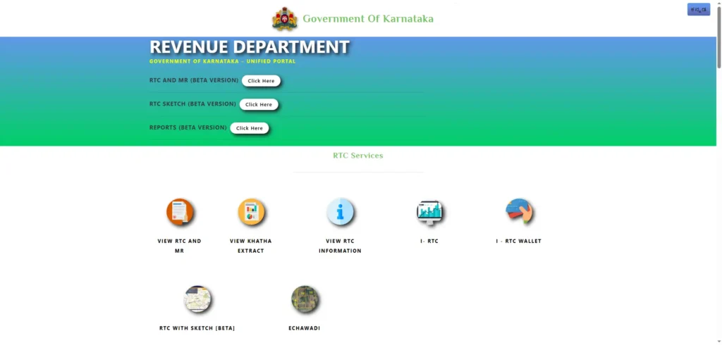
Citizens can access and verify records via the official portal at landrecords.karnataka.gov.in.
- Navigate: Go to “Citizen Services” and select “View RTC and MR.”
- Input Details: Select the District, Taluk, Hobli, Village, and Survey Number.
- Fetch: Click “Fetch Details” to view the current or old year RTC.
- Official Copy: To obtain a legally valid, digitally signed document, users must pay a nominal fee of INR 15.
For those without internet access, these records are available at over 900 Atalji Jana Snehi Kendras (AJSK) and more than 6,000 Gram Panchayat centers statewide.
Demystifying the Mutation Process
Mutation is the process of updating ownership or rights in the land database following a transaction, inheritance, or partition. In Karnataka, the Bhoomi-Kaveri integration allows for automatic mutation initiation once a property is registered.
The scale of this system is immense: approximately 1.2 million mutations are approved annually. Furthermore, the project is economically sustainable, generating nearly INR 25 crore in user charges every year.
How to Check Mutation Status:
- Visit the Bhoomi portal and select “Mutation Status.”
- Enter the Acknowledgement Number (issued at the Application Kiosk) or the Survey Number.
- The system operates on a First In First Out (FIFO) basis, ensuring transparency and preventing favoritism or unnecessary delays.
Technical Sketches: 11E, Phodi, and Hadbust
To satisfy the Curtain Principle, the system-generated sketches in the Mojini II database “pull back the curtain” on boundaries, removing the need for buyers to conduct manual historical research. Manual sketches are strictly prohibited to prevent boundary fraud.
- 11E Sketch: A pre-mutation sketch showing the boundaries of an existing survey number where only a portion is being conveyed.
- Phodi Sketch: Depicts proposed boundaries for individual holdings within a single survey number (used in multiple-owner RTCs).
- Hadbust Sketch: Identifies the exact, confirmed boundaries of an individual’s land holding.
These sketches protect the buyer’s interest by confirming that the land extent claimed on paper actually exists on the ground before the transaction is finalized.
Revenue Maps and Land Conversion
Citizens can view Revenue Maps online to identify village boundaries and the exact dividing lines of various land patches. This is vital for verifying if a plot encroaches on public land or lakes. Additionally, the process for Land Conversion (changing land use from agricultural to non-agricultural) has been digitized, allowing owners to apply and track their status with full transparency.
Offline Access: AJSK and Gram Panchayat Centers
The government maintains a robust physical infrastructure to serve the rural population through over 900 AJSK centers and 6,000+ Gram Panchayat centers. Available documents include:
- RTC (Pahani)
- Mutation Extract and Status
- Tippan (Survey document)
Addressing Challenges: Errors, Privacy, and the Village Accountant
While Bhoomi is a milestone, a professional consultant must acknowledge its remaining risks:
- The Village Accountant’s Influence: Despite digitization, Village Accountants remain the primary source of manual data entry. They still hold a “slight upper edge” in deciding cases where ownership is disputed, leaving room for potential manipulation.
- Inbuilt and Mass Errors: During the initial digitization, mass data-entry errors occurred. To rectify these, the government holds Kandaya Adalats (Revenue Courts). Conducted at the Gram Panchayat level, the Assistant Commissioner of the subdivision is the competent authority to issue on-the-spot correction orders for 16 types of issues, including name mismatches and survey number errors.
- Privacy Vulnerabilities: The current “open-access” nature of the portal allows anyone to view records by simply entering a survey number, which has raised concerns regarding individual privacy.
Conclusion: The Future of Land Ownership in Karnataka
Bhoomi has redefined the socio-economic identity of Karnataka’s farmers. By merging textual records with digital maps, the state is moving toward a truly Integrated Land Information Management System. This evolution promises a future of absolute land titling, where the state-guaranteed record effectively eliminates property disputes through total digital transparency.
Frequently Asked Questions (FAQs)
What is the fee for an RTC?
The official fee is exactly INR 15.
Can I get an RTC at a Gram Panchayat?
Yes, they are available at over 6,000 Gram Panchayat centers across the state.
What is the “11E Sketch”?
It is a pre-mutation boundary sketch that marks the specific portion of a survey number to be conveyed.
Is an online RTC legally valid for bank loans?
Yes. Banks have direct online access to Bhoomi data to verify ownership and liabilities before disbursing loans.
How is mutation initiated?
Mutation is typically initiated automatically after registration through the integration between the Bhoomi and Kaveri systems.