
The digitized landscape of real estate in Kerala has underwent a massive administrative revolution. Traditionally, verifying ownership, obtaining land tax receipts, or downloading survey sketches meant making multiple time-consuming visits to the local Village Office, Taluk Survey Office, and Sub-Registrar’s Office. This separated workflow often meant that textual registers and spatial boundary maps did not reflect real-time property transactions, leading to delays, boundary disputes, and clerical errors.
To bridge this critical gap, the Government of Kerala launched Ente Bhoomi, the front-facing citizen portal of the Integrated Land Information Management System (ILIMS). This platform unifies the three core pillars of land governance—the Revenue, Registration, and Survey Departments—under a single, cohesive, digital umbrella. This ultimate guide provides a comprehensive walkthrough on how to navigate the Ente Bhoomi portal, retrieve essential land documents like the Record of Rights (RoR) and FMB sketches, raise digital resurvey disputes, and implement remote property management strategies to protect your real estate assets.
What is the Ente Bhoomi Portal?
The Ente Bhoomi portal is Kerala’s flagship e-governance platform designed to deliver secure, transparent, and efficient land administration services online. Built by the National Informatics Centre (NIC) Kerala, the portal represents a complete digital transformation of land management. The core philosophy guiding the mission is simple: “Land for all, records for all the land, and all services smart”.
Historically, Kerala’s cadastral records were maintained as paper maps prepared using traditional surveying equipment like chains, cross-staffs, and theodolites, dating back as far as 1905. Because these legacy maps were physically degraded and lacked a universal georeferenced coordinate system, digitizing them to modern WGS84 standards was legally and technically impractical. Ente Bhoomi overcomes this structural limitation by systematically replacing manual, paper-heavy workflows with a centralized geodatabase.
The Architectural Backbone of Ente Bhoomi (ILIMS)
Behind Ente Bhoomi’s clean user interface sits the highly sophisticated Integrated Land Information Management System (ILIMS), built on a robust microservices architecture. This system is structured to execute real-time cross-departmental transactions smoothly:
- Ente Bhoomi Portal: The unified, single-window citizen portal where landholders can query and initiate transactions.
- ILM Gateway: An internal API gateway that securely routes data and coordinates requests across individual department microservices.
- Integrated Land Transaction (ILT) Service: Operating as the transaction broker and workflow engine, the ILT coordinates inter-departmental transfers. Upon initiation of any transaction, the ILT generates a unique Land Transaction Identification Number (LTIN), allowing users to track progress transparently.
- Integrated Land Bank (ILB): A centralized digital repository containing all updated land records, registered deeds, georeferenced cadastral maps, Unique Thandaper numbers, and Unique Land Parcel Identification Numbers (ULPINs).
- ReLIS (Revenue Land Information System) Service: The Revenue Department’s backend, handling land tax collection, basic tax registers (BTR), and the Land Records Maintenance (LRM) module.
- PEARL (Package for Effective Administration of Registration Laws) Service: The Registration Department’s database, tracking registration status and managing document deed records.
- RMIS (Resurvey Management Information System) Service: The Survey Department’s module, housing georeferenced digital map layers and executing spatial queries.
- Single Sign-On (SSO) Service: Built with FIDO-compliant WebAuthn technology, this service integrates access across the three departments securely using password-less passkeys.
The ULPIN and Unique Thandaper (UTR) Explained
Two critical identification keys form the core of Ente Bhoomi’s data standard:
- Unique Land Parcel Identification Number (ULPIN): Often referred to as the “Aadhaar card for land,” the ULPIN is a 14-digit alphanumeric identifier assigned automatically to every distinct spatial land parcel in the state. Generated through GIS-based polygon calculations, the ULPIN prevents overlapping boundaries and establishes clean, digital parcels.
- Unique Thandaper Record (UTR): In Kerala’s revenue vocabulary, a Thandaper number is the unique tax assessment number assigned to an individual’s property holdings inside a specific village. Formerly, if an individual owned multiple, non-contiguous plots in a village, they might have had scattered entries. Under the integrated ILB, the Unique Thandaper (UTR) aggregates all land parcels owned by a single individual within that village into a single, easily traceable tax profile.
Key Features and Services Offered on Ente Bhoomi
The unified Ente Bhoomi platform consolidates an array of essential land-related services that once required physically visiting different department desks.
1. Land Record Search and ROR Downloads
The Record of Rights (RoR) is the definitive revenue document that registers land ownership, area specifications, and tax obligations. Through Ente Bhoomi, registered users can search, verify, and download ROR extracts online. Each ROR extract contains:
- Owner/Possessor Name: The legally recorded tax-paying holder.
- Thandaper Number: The designated tax assessment number.
- Survey and Subdivision Numbers: The spatial reference identifiers.
- Extent: The precise area of the holding calculated in hectares and ares.
- Classification: The land’s dry/wet designation (Nilam or Parambu).
- Tax Details: The basic annual tax assessment.
- Remarks: Critical notations regarding disputes, B-memos, or court attachments.
2. Digital Pre-Mutation Sketches & Auto-Mutation
In traditional land sales, a buyer would register a deed, then submit a separate manual request to the Village Office to initiate land mutation (pokkuvaravu)—the formal updating of ownership in the revenue records. This gap between deed registration and revenue updates was a common source of land disputes and transaction delays.
Ente Bhoomi solves this by executing auto-mutation immediately upon deed registration. The process works as follows:
- Prior to registration, the buyer or seller requests a digital pre-mutation sketch through the RMIS system via Ente Bhoomi.
- The Survey system prepares the georeferenced pre-mutation sketch to match the exact physical boundaries being sold.
- During deed registration at the Sub-Registrar’s Office, the PEARL database accesses this pre-mutation sketch.
- Once the sale deed is registered, the PEARL system triggers an automated API call to the ReLIS database.
- ReLIS executes the auto-mutation (pokkuvaravu) instantly, updating both the textual Thandaper tax registers and the spatial cadastral map layers in real time. No manual application at the local Village Office is required.
3. Integrated Land Tax and Property Tax Payments
Paying basic land tax (Basic Tax Receipt) is a recurring duty for every landowner in Kerala, serving as critical proof of active possession. Ente Bhoomi integrates land tax payments directly through ReLIS, allowing users to clear liabilities using secure online payment gateways and download digital tax receipts immediately. For municipal building and property taxes, the platform integrates with the K-SMART and Sanchaya portals, centralizing all property-related financial obligations under one roof.
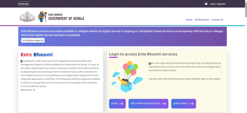
Ente Bhoomi Profile Registration & Aadhaar eKYC Guide
To access the portal’s advanced services—such as downloading verified land maps or filing complaints—citizens must create a secure personal profile and link it to their Aadhaar card.
How to Register and Set Up Your Profile Online
- Visit the official website: Go to the authorized URL:
entebhoomi.kerala.gov.in. - Access the Citizen Portal: Click on Citizen Login and select the registration option.
- Provide Primary Details: Enter your active mobile number and complete the CAPTCHA security verification.
- Verify via OTP: Input the One-Time Password (OTP) received on your mobile phone and click Verify OTP.
- Create Your Password: Set up a secure password to complete the initial account setup.
- Log In and Complete Profile: Log in using your registered mobile number and password. Navigate to your Profile Dashboard (via the profile icon in the top right corner) and complete all fields—including your full name, permanent address, gender, and email address.
Critical Step: Aadhaar eKYC and Mobile Number Linking
To ensure maximum security and protect landowners from fraudulent claims, Ente Bhoomi restricts advanced services unless the profile is verified using Aadhaar eKYC.
- Automatic Linking: If the mobile number used to create the Ente Bhoomi profile matches the mobile number provided and OTP-verified to surveyors during the active digital land survey, the linked properties will be imported and displayed automatically on your dashboard.
- Manual Village Office Approval: If you did not complete OTP verification during the digital land survey, or if you changed your mobile number, your properties will show as “Unverified”. In this scenario, you must visit your local Village Office (or submit an online request) to secure eKYC (Aadhaar Linking) approval from the local Village Officer. Once approved, the verified properties will appear under the “My Properties” tab on your portal.
How to Search Kerala Land Records Online
Once logged in, searching and verifying land holdings is a highly structured, straightforward process.
1. Searching by Survey Number (The Most Precise Method)
Searching by survey number is the most reliable way to target a specific spatial parcel. To perform the search:
- Log in and navigate to the Land Information Search or My Properties section.
- Select the hierarchical geographical parameters from the drop-down menus: District, Taluk, Revenue Village, and Block Number.
- Enter the specific Survey Number and Subdivision Number.
- Complete the CAPTCHA and submit.
- The portal will display the exact land details, including calculated area, recorded owner name, and soil classification.
2. Searching by Owner Name or Thandaper Number
If the exact survey details are unknown, users can query records by entering a registered owner’s name or a unique Thandaper number. When searching by name, users must exercise caution: common name duplications within a village are frequent, making it essential to cross-check results with physical sale deeds or old tax receipts to ensure accurate identification.
3. Downloading FMB Sketches and Cadastral Maps
A Field Measurement Book (FMB) sketch is the official physical drawing showing the exact boundaries, dimensions, and shape of a survey plot. It is the only document in the Kerala land record set that physically maps the parcel.
To view and download an FMB sketch on Ente Bhoomi:
- Go to the Survey Records or Resurvey / Map section.
- Input your location parameters (District, Taluk, Village, Block, and Sheet Number).
- The portal will render an interactive preview of the FMB geodatabase layer.
- To download the certified resurvey FMB file, users pay a nominal fee (typically Rs. 750 inclusive of taxes) through the integrated e-Treasury system.
- Upon payment verification, the complete map is made available as a high-resolution PDF for immediate download.
Understanding the Kerala Digital Resurvey Mission
Many landowners in Kerala are confused by the difference between a routine property search and the state’s active Digital Resurvey Mission.
Traditionally, only 913 out of Kerala’s 1,666 villages had completed old-format paper resurveys. These legacy surveys relied on manual chains, resulting in cumulative positioning errors, boundary shifts, and detached FMB sketches. To establish absolute georeferenced coordinates, the Government of Kerala launched a massive state-wide digital survey to cover all remaining villages using advanced geodetic equipment.
Advanced Geodetic Technologies: CORS, RTK, and Drones
Given Kerala’s challenging, hilly terrain and heavy tree canopy, the Survey Department utilizes a hybrid technology framework:
- Continuously Operating Reference Stations (CORS): The geodetic backbone of the mission, comprising a robust network of 28 permanent CORS base stations covering over 80% of the state. CORS continuously tracks satellite signals to deliver positional accuracy within 3 to 5 centimeters.
- Real-Time Kinematic (RTK) GNSS Rovers: Handheld satellite receivers used by on-field surveyors to log boundary corner points (Geo-codes) in real time by connecting to the CORS network. Approximately 60% of the state’s area is surveyed using CORS and RTK.
- Robotic Total Stations (R-ETS / RTS): Electronic optical instruments that perform automated angle and distance measurements. Since RTK rovers require a direct line of sight to satellites, R-ETS is used in dense forest tracts, deep valleys, and heavy tree-cover zones, covering 20% of the state.
- Drones and LiDAR: Used to capture high-resolution orthophotographs and topographic 3D maps over large open spaces, backwaters, rivers, and flat coastal plains, accounting for the remaining 20% of the state.
The “Unsurveyed” Tag: Common Rural Anomalies
During the rollout of the digital survey, some areas—especially in high-range, mountainous farming districts like Kozhikode—experience temporary operational friction. When physical ground measurements are completed by field surveyors, there can be a delay of several months before these new spatial polygons are fully synchronized, checked for topological overlap errors, and approved by the Assistant Director of Survey to be pushed to the public ReLIS database.
During this lag, the property may carry a temporary “Unsurveyed” tag on the portal. Since banks and registration systems rely on real-time database lookups, an un-synced “unsurveyed” status can temporarily freeze a landholder’s ability to sell, partition, or secure agricultural crop loans on their property. If your land carries this tag, you should contact your local Taluk Survey Office to check the status of block map validation.
Dispute Resolution: How to File Resurvey Complaints Online
If the digital survey creates an incorrect boundary map, assigns your land to a neighbor, or contains errors, Kerala’s survey laws provide a clear, structured system to file corrections.
Step 1: Original Land Complaints (OLC) & Survey Sabhas
The Original Land Complaint (OLC) stage is the first line of defense, taking place during active field measurements before any formal records are published.
- Survey Sabhas: Before field work begins, the Survey Officer conducts a ward-level public meeting under the chairmanship of the Gram Panchayat President to display schedules and notify the public.
- Filing OLC: If you observe an error during boundary stones planting, you can file an OLC online or in person.
- OLC Registry: All OLCs are formally registered at the Survey Headquarters in Form No. 66 (for village boundary disputes) or Form No. 67 (for individual field boundary disputes).
- Investigation: The complaint is referred to a Head Surveyor, who issues a formal summons in Form No. 71 to the defendant and Form No. 72 to any witnesses, convening an on-field enquiry to take sworn depositions under the Code of Civil Procedure. The final decision is communicated to both parties in Form No. 5.
Step 2: Appeal Land Complaints (ALC) and Section 11 Appeals
Once the primary OLC cases are settled, the Survey Department publishes a preliminary boundary notification under Section 9(2) of the Kerala Survey and Boundaries Act, exhibiting the block maps at camp offices for public inspection.
- The 30-Day Window: Landholders have a strict 30-day window from the date of Section 9(2) publication to file an Appeal Land Complaint (ALC) in Form No. 160 if they identify any unresolved discrepancies.
- ALC Registry: ALCs are registered under Form No. 68 or Form No. 69.
- Resolution: The appeal is evaluated by an appellate authority (typically the Survey Superintendent or Assistant Director). The officer conducts a site inspection, takes decisions, and coordinates the correction of the digital block layers under their secure login credentials.
- Civil Court Recourse: If the ALC is dismissed, the landholder’s statutory recourse is to file a partition or boundary declaration suit in a competent Civil Court under Section 14 within the prescribed limitation period.
Step 3: Land Records Maintenance (LRM) Module
Once all appeals are resolved, the Assistant Director publishes the final boundary record under Section 13 of the Act. Section 13 serves as conclusive legal proof that boundaries have been correctly determined unless modified by a Civil Court decree.
If errors, name mismatches, or area discrepancies are discovered after the final Section 13 publication, citizens cannot file standard OLC or ALC complaints. Instead, they must submit a formal application through the Land Records Maintenance (LRM) Complaint Module on Ente Bhoomi. The LRM coordinates corrections across the Revenue and Survey databases, routing the file to the Taluk Survey Office for ground verification and correction of the Fair Land Register.
Remote Property Management for NRIs: A 10-Step Vigilance Checklist
For Non-Resident Indians (NRIs) and absentee landowners, managing land holdings in Kerala from abroad carries significant risk. Because digital records can be updated or corrected under administrative workflows, remote owners must maintain active vigilance over their assets. Below is the definitive 10-step remote management checklist designed to secure your property:
1. Perform Annual Registry Audits
Set a recurring calendar reminder to log in to Ente Bhoomi once every year. Run a search using your District, Taluk, Village, Block, and Survey numbers to verify that your ownership name and Thandaper details remain correctly recorded.
2. Verify Your Aadhaar eKYC Status
Confirm that your Ente Bhoomi profile displays your properties under the “My Properties” tab. If they do not appear, submit your physical sale deeds to the Village Officer to secure Aadhaar eKYC linking approval immediately.
3. Track Your Encumbrance History
Apply for a certified 30-year Encumbrance Certificate (EC) online through the PEARL portal annually. This ensures no unauthorized mortgages, liens, or court attachments have been registered against your survey number without your knowledge.
4. Cross-Reference Spatial Boundaries via BhuNaksha
Access the BhuNaksha module (emaps.kerala.gov.in) to visually inspect the digital boundary map of your survey number. Ensure that your parcel polygon has not suffered any digital deformation, unexpected offsets, or overlaps with public roads or neighbors.
5. Maintain Timely Tax Records
Pay your basic land tax on ReLIS and property/building tax on K-SMART annually. Keep digital copies of all tax receipts, as a continuous chain of tax receipts is primary evidence of your active possession in revenue courts.
6. Restrict GPoA Delegations
Never issue a broad, open-ended General Power of Attorney (GPoA) to relatives or local agents. If you must delegate physical tasks, issue a narrow, transaction-specific Special Power of Attorney (SPoA) that clearly defines the permitted actions.
7. Formally Register Your SPoA
Ensure your SPoA is executed, notarized, and attested by the nearest Indian Embassy or Consulate. The document must be formally registered at the relevant Sub-Registrar’s Office in Kerala within three months of execution to be legally valid.
8. Monitor Statutory Ceiling Limits
If you inherit ancestral properties, verify that your total cumulative land holdings in Kerala do not exceed the ceiling limits (typically 15 acres for a family) set by the Kerala Land Reforms Act, 1963. Holdings exceeding these limits are subject to government acquisition.
9. Conduct a Professional Boundary Survey
Commission a licensed surveyor to perform a physical boundary measurement of your land, planting concrete boundary stones firmly. Erect strong physical fences around the plot, as clear physical demarcation is necessary to successfully defend against trespass.
10. Demonstrate Active Possession (Animus Possidendi)
Under Indian property law, absentee owners are vulnerable to adverse possession claims if a third party occupies the land continuously for 12 years. As highlighted by the Supreme Court of India in Government of Kerala v. Joseph, you must demonstrate active possession (animus possidendi)—an explicit, documented intention to exclude others and possess the land as your own. Keep the property clear of overgrowth, maintain gates, and document annual visits.
Ente Bhoomi Kerala FAQ
Is Ente Bhoomi data legally valid as proof of ownership?
No. Ente Bhoomi is a revenue registry maintained to track tax liability and possessory details. Under Indian law, an ROR extract or Thandaper receipt indicates possession and tax obligation, but it does not constitute absolute legal title. Your primary proof of ownership remains your registered sale deeds, clean mother deed chains, and clear encumbrance histories from the Sub-Registrar’s Office.
Can common citizens draft and register property deeds directly on the portal?
No. While PEARL utilizes standard template-based registration, the system currently restricts deed preparation and submission to licensed document writers and advocates in the first phase. This is to prevent technical errors, valuation mistakes, and legal anomalies that common users might struggle to navigate.
How do I resolve a name or area mismatch on Ente Bhoomi?
If you find a name misspelling or an area mismatch on the portal compared to your sale deed, you must file a formal correction request. Navigate to the LRM Complaint Module on Ente Bhoomi, submit a digital application, and visit your local Taluk Survey Office with your physical sale deeds, original tax receipts, and a certified FMB map to request a boundary refixing and record correction.